Drone Hive
What is LiDAR and Why is it Important for Drones?
The Advanced Aerial Technology That Is Paving the Way for 3D Mapping, Self-Driving Cars and More
In this article:
- The Core Principles Of The LiDAR Technology & Brief History
- LiDAR (Light Detection And Ranging) As An Emerging Method Of 3D Mapping And Examining Geographical Surfaces
- The Main Benefits OF The LiDAR Technology (Compared To Conventional Technologies)
- Practical Applications Of LiDAR Technology: How This Technology Shapes Our Future
Let’s face it – drone and related technologies are developing rapidly and disrupting many industries. Perhaps none more so LiDAR, an advanced remote sensing methods which is proving invaluable for surveillance, mapping of the Earth and accurately measuring large spaces.
The Core Principles Of The LiDAR Technology & Brief History
LiDAR originated in the early 1960s as a technology that would examine meteorology, used by the National Center for Atmospheric Research to measure clouds. The technology was later developed to its current form. The general public became aware of the technology and its accuracy in 1971 during the Apollo 15 mission, when astronauts used a laser altimeter to map the surface of the moon.
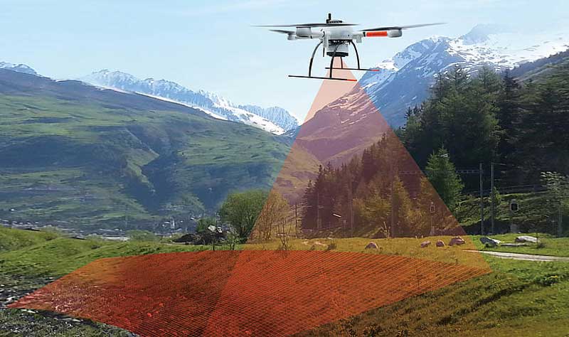
The main principle of the LiDAR technology is the laser-illuminating feature that targets and analyzes the reflection. The LiDAR instrument fires rapid pulses of laser light at a surface (up to 150,000 pulses per second) and is preferential to conventional lasers due to the much shorter wavelength, meaning it can accurately measure even the smallest of objects.
https://www.youtube.com/watch?v=RW5ONf7DtyY
LiDAR (Light Detection And Ranging) As An Emerging Method Of 3D Mapping And Examining Geographical Surfaces
LiDAR, or Light Detection And Ranging, is a sensing method that uses light in the form of a pulsed laser in order to measure ranges (variable distances) to the Earth. As such, it allows precise generation of three-dimensional information about specific areas or surfaces.
The basic LiDAR instrument combines a laser, an IMU (Inertial Measurement Unit) and a specialized GPS receiver. Surfaces and objects are best done so from above, hence why airplanes and helicopters are one of the most common examples of objects that acquire LiDAR data in broad areas.
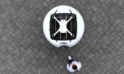
As of recently, however, the use of LiDAR technology has also been adopted by drones. In addition to being cheaper to deploy than airplanes and helicopters, the process of flying a drone has a smaller learning curve, and does not require adherence to as many regulations, licensing as so on. Thanks to the adoption of LiDAR technology by drones, many scientists and mapping professionals can obtain accurate data that helps them examine environments in a flexible, precise and more affordable way.
The Main Benefits OF The LiDAR Technology (Compared To Conventional Technologies)
Even though there are not many visible technologies that can be compared to LiDAR, the other known methods for collecting topographic information include GPS, land surveying, interferometry and photogrammetry.
While all these methods are well established, LiDAR technology offers many more advantages over the older technologies. Here are listed the main advantages of LiDAR over the other conventional technologies:
- Higher Accuracy – LiDAR has a higher vertical accuracy (5-15 cm) and higher horizontal accuracy (30-50 cm) as well.
- Fast Processing – LiDAR has an acquisition range of 1000 km2 in 12 hours and is able to generate DEM of 1000km2 in 24 hours.
- Minimum Dependence – What sets LiDAR apart from conventional technologies is the fact that it needs minimum human dependence, all thanks to its automatic processes.
- Weather/Light Independence – Another big advantage of LiDAR is the weather and light independence. The technology is independent of sun inclination or bad weather at night.
- Canopy Penetration – The LiDAR pulses have greater penetrative abilities, being able to reach beneath the canopy and generate measurements of points unlike conventional photogrammetry.
- Superior Data Density – LiDAR is able to measure up to 167,000 pulses per second – this is equal to over 24 points per m2 measured.
- GCP Independence – LiDAR is ideal for mapping various areas – even inaccessible and featureless ones – mostly because of its GCP independence as reference receivers for the purpose of DGPS.
- An Extra Set Of Data – Aside from the standard information, LiDAR also gathers data in the form of amplitude of backscatter energy, recording a reflectance value for each data point – something that can be used for classification.
- Cost – Last but not the least is the cost of LiDAR, which makes the technology cheaper in many applications – not to mention its improved speed, accuracy and density of data.
The benefits of LiDAR are numerous – bringing 3D mapping and surveillance to a whole new level.
Practical Applications Of LiDAR Technology: How This Technology Shapes Our Future
The use of the LiDAR technology began in space more than 50 years ago. However, today LiDAR is best known for its use in agriculture, creating a topographical map of the fields and revealing the slopes and sun exposure of the farmland.
Aside from this, the use of LiDAR in precision agriculture can be also seen through crop mapping in orchards and vineyards – where it indicates the areas where fertilizers should be applied for achieving the highest crop yield.
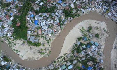
The use of LiDAR in geology, soil, climate and ocean science is best seen when measuring topographic features such as ocean beds, river terraces, river channel banks, glaciers and the level of change on our environment year after year.
-

- A digital elevation map of a bay in Robeson County, NC. Vertical resolutions of centimeters allow for visualization of the form and extent of the bays’ otherwise imperceptible rims | Credit: Michael Davias
-
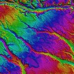
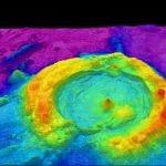
- High-resolution multibeam lidar map showing spectacularly faulted and deformed seafloor geology, in shaded relief and coloured by depth | Wikicommons/NOAA
LiDAR systems are also used in meteorology, for example to produce cloud profiles, measure winds, and study/quantify aerosols, gases and other atmospheric components.
LiDAR can also be used to calculation ore volumes, making it extremely useful in the mining industry, where the sensors may also be used for obstacle detection and avoidance (e.g. for robotic mining vehicles).
LiDAR technology is also proving useful in utilities and pipeline inspection, where the combination of UAV aerial data and LiDAR can produce very high resolution results. In this video, anomalies in the vegetation encroachment along the infrastructure’s corridor were detected with 100% accuracy.
As of recently, the LiDAR technology was also tested in autonomous vehicles for obstacle detection and avoidance. This has paved the way to a future of autonomous vehicles and safer navigation in all types of environments.
A Final Word
In the end, it is safe to say that LiDAR has paved the way to a new future in many different industries. From agriculture to surveying, 3D mapping, robotic mining and autonomous driving, the technology is set to disrupt many conventional rules and become one of the most important technologies to ever be invented.