
News
AirMap Extends Low-Altitude Authorization Capabilities to All Drone App Developers
AirMap Extends Low-Altitude Authorization Capabilities to All Drone App Developers
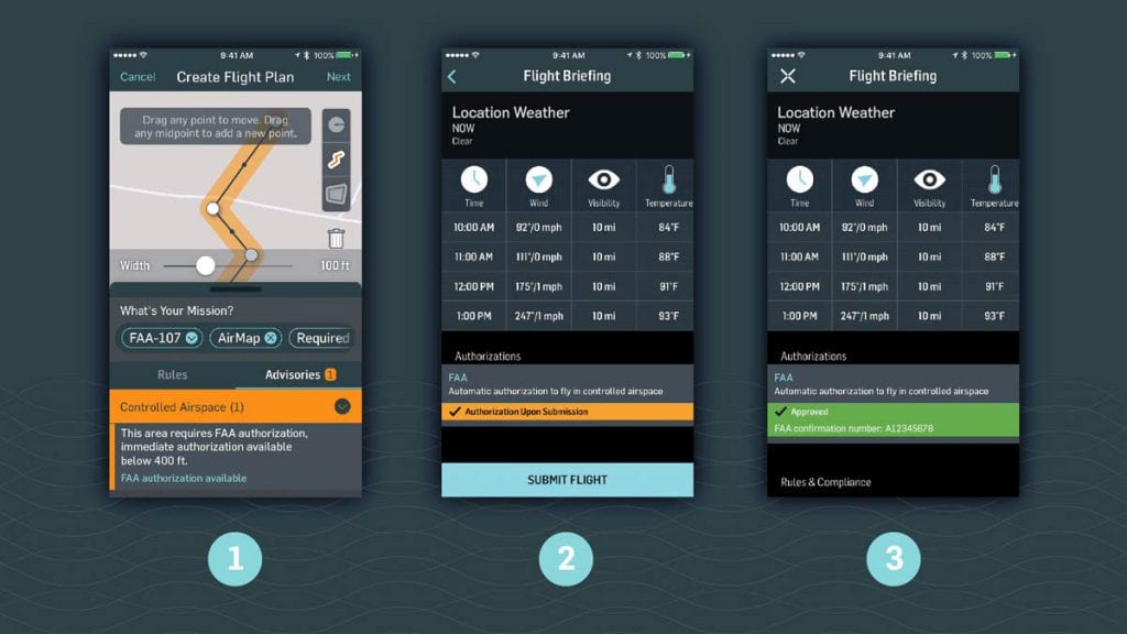
LAANC – short for Low-Altitude Authorization and Notification Capability – is now available for drone software developers worldwide thanks to Airmap, the global leader in airspace management platform for drones who just announced this feature. This means big things for the drone industry. With the FAA’s LAANC initiative, drone operators finally have the option to gain digital authorization to fly in U.S. controlled airspace near select FAA facilities.
In participating apps, drone operators use their AirMap account to transfer flight plan information to the AirMap app with just a tap. Airmap processes the authorization request, and once approved, drone operators are directed back to the originating app at which time they can have legal authorization from the FAA complete their flight. The ability to integrate existing drone apps in this manner is made possible through Deep Linking, meaning that drone developers and manufacturers can now integrate LAANC from AirMap into any app they like.
Source: AirMap
LAANC is now available at six FAA facilities, which includes 46 airports. The LAANC prototype will be developed into a national beta by the FAA come April, and by the years’ end, it is envisioned that more than 500 towered airports across the USA will join the original cohort of airports offering LAANC authorization. This is great for drone operators as a whole – lengthy application processes as mush as 90 days to acquire waivers to fly in U.S. controlled airspace will eventually be a thing of the past. Using LAANC, drone flights at certain altitudes will be able to be authorized almost immediately, expanding controlled airspace for commercial missions by thousands of miles, and thus also the drone economy.
Industry innovators 3DR, Betterview, Converge, and DroneDeploy are the first to deploy LAANC Deep Linking from AirMap, now available to all with AirMap’s developer platform.
Two more integrations are due to launch next month. The first is DroneBase, which is an affordable and scalable solution that makes available drone image and data to enterprises via its global pilot network. Along with that is DAAS (Drone as a Service®) company Measure, which provides to enterprises the ability to acquire, process, and deliver actionable aerial data.
“With the LAANC beta launching nationwide by the end of the year, AirMap’s deep linking feature will bring digital authorization to an entire community of U.S. drone operators and developers eager to reach new heights,” said Ben Marcus, CEO of AirMap. “Thanks to LAANC, more airspace is open for business, and commercial drones have more opportunities to contribute to our economy and benefit our daily lives.”
“With this integration, it’s easier than ever for our customers to fly safely and confidently in the FAA’s controlled airspaces,” said Chris Anderson, CEO of 3DR. “This is a big next step in making commercial drones an essential tool on projects across the country.”
“AirMap’s new LAANC Deep Linking has the potential to unlock greater operational efficiency for thousands of DroneDeploy customers across the construction, agriculture, and insurance industries,” said Ian Smith, Business Development Lead at DroneDeploy.
AirMap’s drones provide airspace management for any environment, automatically logging past, present & future flights. Drones using AirMap airspace management solutions can access live positioning and aircraft health data for complete situational awareness in managed airspace, schedule automated authorization for pre-approved flight plans and manual authorization for flights outside pre-approved zones. Airmap’s Airspace Management Dashboard can also manage a fleet with dynamic deconfliction and telemetry. AirMap has successfully brought complex UTM services to markets worldwide, including Switzerland, Kansas, and Japan in the past.


