Drone Hive
What is Wide Area Augmentation System (WAAS)?
WAAS, or Wide Area Augmentation System, is an accurate navigation system that has been designed for civil aviation.
Before its official production for civil industry, WAAS was used by the US National Airspace System (NAS) which until the development of the technology did not have the potential to provide horizontal and vertical navigation for all users at all locations.
The WAAS was developed as a solution to this problem – providing services for route navigation, airport departures as well as airport arrivals, for all classes of aircraft in all phases of flight including high-endurance unmanned aircraft systems.
Revolutionizing The Conventional GPS Technology In A New Format
Currently, WAAS is the most precise location-providing service that is available in North America. It was developed by the Federal Aviation Administration (FAA) has teamed with the Department of Transportation (DOT) with a view to implementing the WAAS throughout the aviation industry, to make flying more efficient and safe for users.
The benefit of the WAAS over conventional and regular-old GPS technology, is that although GPS is probably the most error-proof navigation technology (NAVAID) on the market, like all systems it has inherent insufficiencies. GPS data is vulnerable to a few different errors such as timing errors, disturbances from the ionosphere as well as satellite orbit errors.
Even though these errors do not generally create a major problems when using the GPS technology, they definitely leave room for improvement – which is why the Wide Area Augmentation System (WAAS) was developed. In doing so, a navigation system that meets the FAA requirements for both vertical and horizontal navigation accuracy for precision approach procedures is now available to both military and civilian aircraft systems.
How Does The WAAS Technology Work?
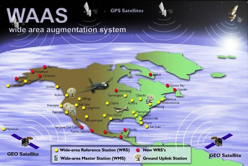
The WAAS technology uses 25 widely spaced ground-based stations based all over the United States in order to monitor its satellites, as well as newer bases established throughout the United States, Canada and Mexico that collect GPS data. There are two Wide Area Master stations as well as 23 Wide Area Reference Stations.
The satellite data from this system is collected at the reference stations and then sent to a master station. The old GPS data is augmented and corrected at the master station – and sent in a form of adjusted data back to the stationary satellites through an uplink station. Then, this data is broadcasted to WAAS-enabled GPS receivers in the form of position data.

WAAS reference stations and satellites | FAA
In order to show the accuracy of WAAS, some comparative metrics are listed below, according to latest benchmarks.
- 100 m: Accuracy of the original GPS system, which was subject to accuracy degradation under the government-imposed Selective Availability (SA) program.
- 15 m: Typical GPS position accuracy without SA.
- 3-5 m: Typical differential GPS (DGPS) position accuracy.
- < 3 m: Typical WAAS position accuracy.
(Source: Garmin.com)
As such, the Wide Area Augmentation System provides ranging signals which are transmitted by GEO satellites. There are differential corrections on the wide area and additional parameters which are aimed to guarantee the integrity of the GNSS user. This includes the following:
- GEO Ranging: transmission of GPS-like L1 signals from GEO satellites to augment the number of navigation satellites available to the users.
- Wide Area Differential (WAD): differential corrections to the existing GPS and GEO navigation services computed in a wide area to improve navigation services performance. This includes corrections to the satellite orbits and clocks, as well as information to estimate the delay suffered from the signal when it passes through the ionosphere.
- GNSS/Ground Integrity Channel (GIC): integrity information to inform about the availability of GPS and GEO safe navigation service.
(Source: Navipedia.net)
Currently, the WAAS satellite coverage is only available in North America (because of the location of the ground stations). However, many countries are taking the initiative to build similar satellite-based systems. For example, in Europe there is the Euro Geostationary Navigation Overlay Service (EGNOS), India has implemented the GPS-aided GEO augmented navigation (GAGAN) and Japan has the Japanese Multi-Functional Satellite Augmentation System (MSAS).
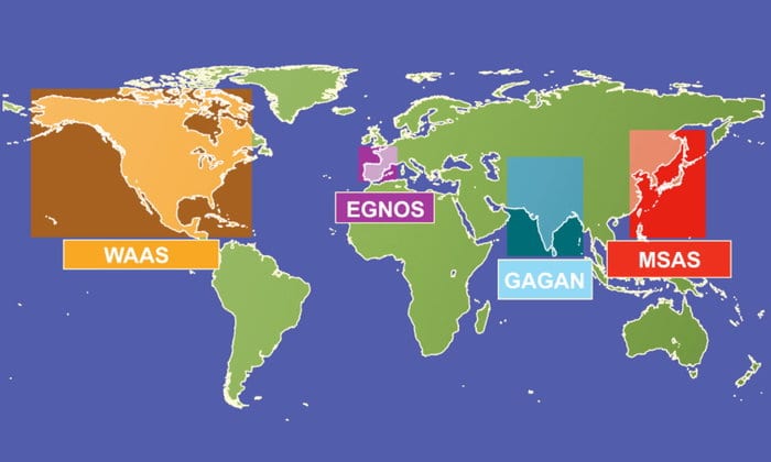
Source: European Space Agency
Which Are The Practical Uses Of The WAAS Technology?
The Wide Area Augmentation System greatly improves the accuracy. While traditional GPS is accurate to 15 metres, WAAS-enabled GPS is accurate to less than 3 metres, 95% of the time.
On top of the accuracy, WAAS utilizes Localizer Performance with Vertical Guidance (LPV) approaches. This makes the national airspace system more efficient. For example, an aircraft that might otherwise be required to fly to an alternate location – can now land with lower weather minimums at the destined location – all thanks to this LPV approach. This results in fewer delays and lower costs.
Thanks to the improved accuracy, there is a massive opportunity for lower separation minimums as well as more direct routes for the aircraft. All in all, WAAS saves a large amount of money on equipment costs. While traditional radio navigation (ILS and MLS) requires expensive equipment and regular and costly maintenance – the new precision approaches that are part of WAAS exclude these costs, resulting in better equipment which requires little to no maintenance.
The Wide Area Augmentation System technology falls within the FAA’s category of Performance Based Navigation (PBN) because the system uses special satellites and onboard equipment in order to navigate. This conducts performance monitoring and can alert the pilots to position errors and improve safety.
In 2016 alone, there were more than 90,000 aircrafts equipped with WAAS and capable of flying any of the 4,000 LPV procedures that were published. The full list of WAAS approaches can be found on the official FAA Satellite Navigation website.
A Final Word
In times when Global Positioning Systems (GPS) and their navigation capabilities are not adequate to support the fast-growing aviation industry, the Wide Area Augmentation System (WAAS) hardware sets a new level for accuracy and precision. Even though the technology receives GPS signals, it forwards them to the Wide Area Master Stations for potential corrections and further processing.
As such, WAAS is a safety critical system which means that any type of misleading information is not allowed – and the time to alarm is critical.