3D scanning and virtual reality increase the quality of environmental monitoring and allows businesses to create interactive floor plans.
When a home is put on sale online, often these days you can tour it using the real estate agency’s 360 degree video.
Museums also produce virtual reality environments, allowing guests via VR glasses to get an impression of how the people of the past lived.
These 3D impressions are created using drones and specially designed cameras.
Today, these technologies are also used in the environmental field of engineering companies; and one such organisation is the Environment and Raw Materials section of Regional Development in Southern Denmark, which has just completed a project in the region’s test area in Rudkøbing, Langeland.
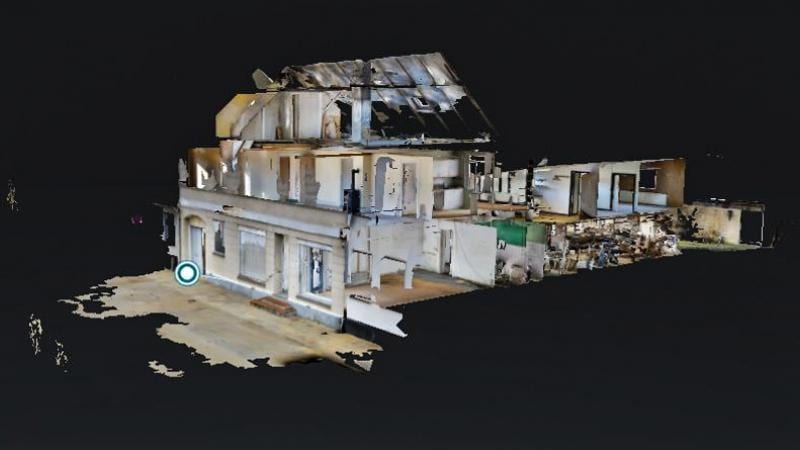
Here it has mapped the contaminated property on Ørstedsgade 26, which was previously a dry cleaner.
Easy and inexpensive mapping
Speaking with Tu.no, civil engineer Kristian Dragsbæk Raun explains in order to map a contaminated property, traditionally the team gets access to floor plans and images of the entire house.
“When we are out on properties, we usually get the counselors to go around and measure up and make a floor plan that is quite accurate.”
But this method is expensive and time consuming.
Instead, using drones, “the company travels and makes the recordings, and then [we] can get a floor plan on the purchase,” he says.
Using the drones to create a 3D model of the building, the engineers can ‘walk around’ the mapped building from the safety of their office.
“If we need to know something about a room, such as where a floor cover is placed and such things, we can use the pictures and see exactly what it looks like. We do not need to go out there again if you forget to mention something. [Southern Denmark] is big, and Rudkøbing is well located away from our offices. So that way we can save time,” says Kristian Dragsbæk Raun.
“The next step with the technology may be that if you have a sampler on a property, we can mark a point where we will have a sample, and then it will appear on the sampler’s phone. So there is also an opportunity for further development in this,” he says.
Environmental surveys: Very simple
Another company, Takeawalk VR, based in Southern Denmark has been responsible for 3D visualization at Langeland.
Three to four years ago, Director Jesper Roy discovered 3D cameras in the United States and began scanning hotels. After a television presentation he was contacted by Danish consulting firm Dansk Miljørådgivning A / S, who said they’d like to use the technology.
“Then we had a long talk about 3D scans and drone 3D surveys. For the first time in my life, I found something that really looked [interesting]: 3D images and engineers who go and make environmental records,” says Jesper Roy.
Drawings by scale
“There are several elements in this. Number one is purely visual. Once we’ve been out there, everything is crawled and documented. Thus, you know how the property looked like at that time. In addition to this, we all have goals on the property, ” he says.
The principle of the 3D recording scanner is briefly that the camera measures the distance from a to b many times. That way, you have distances on everything, and it is on a scale, because you know how many walls exist and how high it is to the ceiling.”
Since our first tests, we have also received 3D measurements from the air, where we perform external measurements, and external VR images with drones and special cameras. As I see it, it’s getting more of this. The methods are used [for much] environmental advice today,” Roy continues.
Drone monitors mass excavation
The Region of South Denmark is also currently using drones in another development project, in a gravel pit in Jutland.
The region tests the 3D camera’s capabilities in terms of monitoring of raw material recovery, so that geologists can see how much is dug out since the equipment can also calculate height differences.
According to geologist Michael Hjort Andersen, drones are quite obvious for documentation in raw materials.
“With drones we can easily determine cliff hills and make volume calculations. In the long run, we hope to be able to do it in gravel grave lakes, to ensure that the fences are built up correctly. And we are participating in a big drone development project called Riverscapes, where one of the development areas is just the use of an active sonar towed after a drone,” says Michael Hjort Andersen.
Chief advisor Christian Andersen from the Region’s Knowledge Center for Environment and Resources ensures that drones and 3D visualization not only enhance the quality of environmental monitoring but also a much more effective method of working. The potential is obvious to the Danish Soil Partnership with Danish Regions, the Danish Association of Danish Environmental Technologies and the Danish Environmental Protection Agency, he believes.
“Many suggest that this will be technology of the future…When you develop ideas somewhere, you also try to develop these within the other regions, because good ideas are spreading.”