News
GPS Precise Point Positioning for Photogrammetry via Drone
Just like many other industries, unmanned aerial vehicles (UAVs) or drones have recently become a popular platform for photogrammetric data acquisition. This is mostly because they are flexible and affordable when compared to manned aerial platforms.
Another important aspect of the efficacy of using UAV imagery is the centimetre-level accuracy using a small number of high-accuracy ground control points (GCPs) which have been traditionally required for the indirect determination of absolute image orientations throughout many processes in this field.
Reinventing the Use of GPS Precise Point Positioning
A new paper published by four authors aims on reinventing the use of Global Positioning System (GPS) precise point positioning (PPP) on a fixed wing unmanned aerial vehicles – all in order to improve the accuracy in planimetry from flights of 25 to 30 minutes in duration.
“Photogrammetry from UAV platforms, unlike manned aerial platforms, usually necessitates the use of structure from motion (SfM) techniques to facilitate the bundle block adjustment. This is because SfM provides efficient and direct solutions (so no requirement for a priori information) to the matching and relative orientation of convergent and non‐metric small‐format imagery. Control information (such as GCPs or camera positions) may then be integrated as additional parameter observations in a rigorous bundle block adjustment, thus conforming to aerial triangulation. The latter step may also be satisfied by a Helmert (three‐dimensional conformal) transformation, but this has limited accuracy because the control information does not help to minimise possible block deformations and systematic errors.”
Just like conventional GPS aerial triangulation, the authors state that if UAV imagery comprises a strong block geometry with a consistent scene texture – the camera attitudes may be computed in the bundle block adjustment with high accuracy.
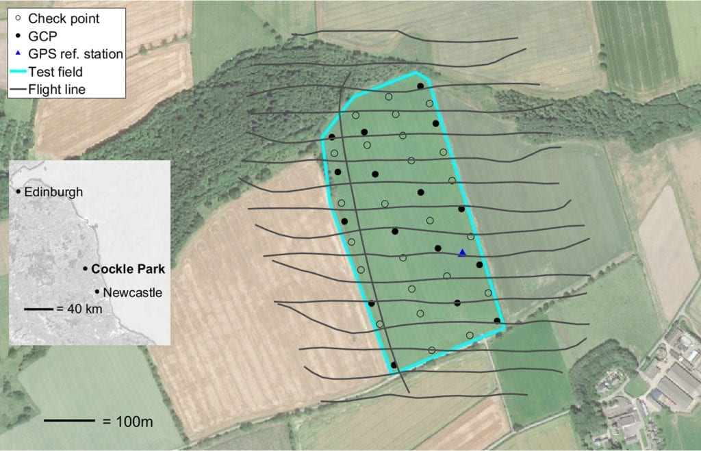
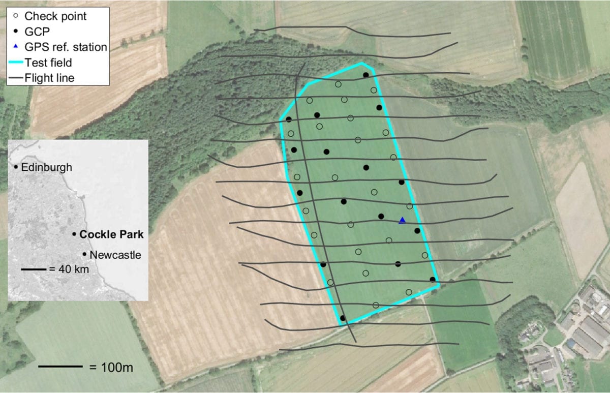
Test field at Cockle Park, Northumberland, north‐east England. Flight lines (for Flight 1 only), location of GCPs, check points and the GPS reference station are shown. Background image: Google Earth.
Factors Influencing the Accuracy of UAV Point Clouds
They also point that a major factor that influences the accuracy of UAV point clouds is the quality of GPS-based camera positions, among which the main factors are block geometry, image measurement quality and ground sample distance (GSD).
In order to obtain GPS-based camera positions with a centimeter-level accuracy, however, the authors suggest that dual-frequency carrier phase and code observations are required.
“If a local GPS reference (base) station is available, relative GPS positioning in the form of post‐processed kinematic (PPK) GPS or, with a radio link, real‐time kinematic (RTK) GPS may be used. In relative positioning, GPS carrier phase observations are double differenced to solve for positions relative to the (known) reference station coordinates. If the baselines are short (less than a few kilometres) and the double differenced ambiguities are successfully resolved to integers, then PPK/RTK GPS positions with centimetre accuracy can result.”
Therefore, the GPS precise point positioning (PPP) technique provides a potential alternative to relative GPS for the determination of camera station positions with centimeter-level precision and accuracy.
The authors also note that to date, the application of GPS PPP for direct georeferencing in airborne mapping has resulted in low accuracy on small UAV platforms – or has been used on manned aerial platforms with flight durations of several hours. Therefore, the aim of their paper is to showcase the methods under which georeferencing of a lightweight and fixed-wing UAV platform can use kinematic GPS PPP.
The Surveys, UAV Missions and Test Fields – and Their Results
Through test field and UAV missions, the authors survey the use of drones in this particular case, taking ground surveys and evaluating all the GPS parameters. Their conclusion is clear and simple – without GCPs, the mapping accuracy definitely differs (in the methods that they showed) and is promising for a number of applications.
Their results are as following:
“An assessment of GPS PPP‐based direct georeferencing on a fixed‐wing UAV for large‐scale photogrammetric mapping has been presented. Such a workflow alleviates all spatial operating constraints associated with the installation and the use of a local GPS reference station, GCPs or the need to operate within the bounds of a permanent GPS reference station network. Results are based on the analysis of two missions of 25 and 29 minutes in duration, at a flying height of 120 m, using a lightweight (~5 kg) fixed‐wing UAV equipped with a digital compact camera.”
Obviously, there are many other conclusions that can be taken from the survey – but the main one is the fact that their method substantially improves the meter-level accuracies that were previously found and tested.
Citation: Grayson, B. , Penna, N. T., Mills, J. P. and Grant, D. S. (2018), GPS precise point positioning for UAV photogrammetry. Photogram Rec. . doi:10.1111/phor.12259 | https://onlinelibrary.wiley.com/doi/full/10.1111/phor.12259


