News
Using Drones to Check Wildlife Tag Location Errors
Using Drones to Check Wildlife Tag Location Errors
Most of the recent studies have shown that drones can have a high potential to function as tools in order to facilitate wildlife radio-tracking, especially in hard-to-access terrains. The data obtained from receivers attached to drones will be of limited use, however will be effective in many ways.
To test this solution, a group of authors decided to study animal movements at local to continental scales – through placing different transmitters at fixed locations. They also decided to fly a quadrotor drone over them along linear segments, adding up to the signal strength. From this, the main aim of the authors was to prove the accuracy of the system and its potential to be used in high-precision purposes such as finding nests.
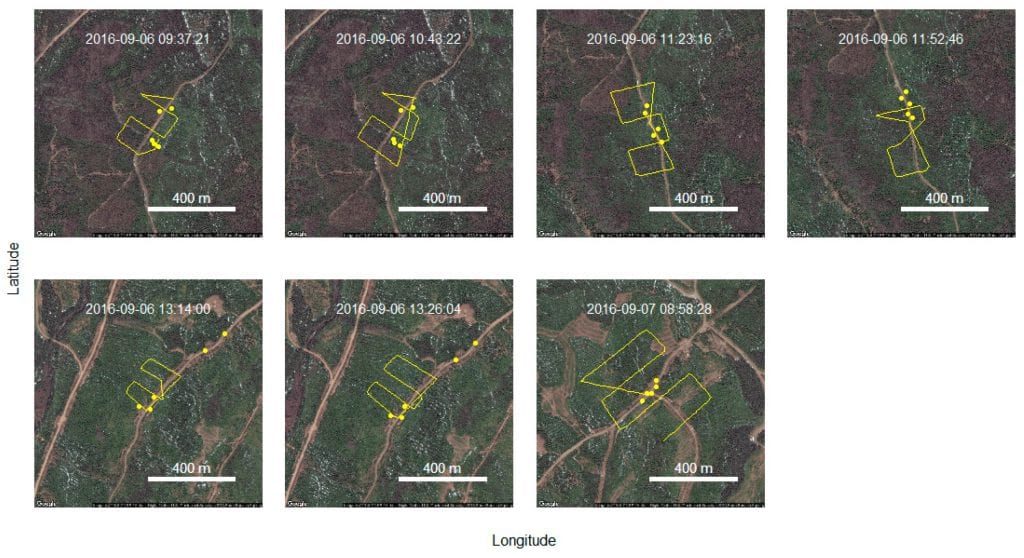
Flight transects and test transmitter locations, in yellow. Takeoff times are indicated.
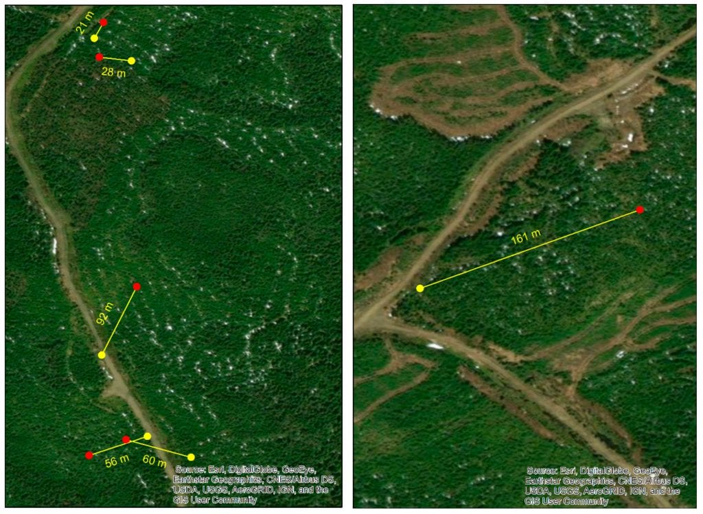
Transmitter location errors from quadratic regression estimation, based on signal strength. Test transmitter locations in yellow, estimated locations in red.
Studying Animal Movements in Different Scales
As the authors state in the introduction of the paper:
“The advent of drones in the civil sector may offer immense potential for combining affordability, safety, and accuracy in the effort to document movements of animals fitted with non-GPS transmitters.”
They are also honest about the concerns of such a system, especially knowing that a solution like this needs t be addressed in order to promote the use of drones in wildlife radio tracking.
“In principle thus, knowing the strength and direction of a transmitter signal from two locations, sufficiently distinct in space and sufficiently close in time, should yield highly accurate positions. However, transmitter signals are dampened by trees, rocks, etc., to varying extents, and may exhibit multipath effects, making it practically impossible to infer transmitter locations from two locations with intervening obstacles.”
This is why their study estimated transmitter location errors with fixed-location “test” transmitters and a drone-borne receiver in a hilly and dense forest that is mostly composed of balsam fir.
Using Five Radio Transmitters at Different Distances to Measure the Signal
Basically, the authors used student equipment and conducted seven flights within two sectors each covering about 0.2 square kilometers and each composed of a matrix of old, mid-successional and early-successional balsam fir stands resulting from clear-cutting. Before each flight, the authors deployed 5 radio-transmitters at different distances. After every flight completed, they downloaded data from the two sources – allowing them to match the signal reception from the test transmitters to the exact location of the drone.
As they found from this:
“Several factors may influence signal reception and strength. However, on average, signal strength should provide an unbiased estimate of the distance between the transmitter and the receiver. Thus, a two-dimensional array, i.e., a map of signal strengths, should inform us about the true location of the transmitter. We estimated the location errors with two methods. First, we retained the drone location at which the signal was strongest, and calculated the Euclidean distance between the drone XY coordinates, and the XY coordinates of the source.”
(Summing Up) The Importance of Distance
The results also show that signal strength decreased significantly with the increasing distance to drone. The main outcome of the study, however, was that drones can be a perfect alternative to the labor-intensive and traditional approaches for radio tracking.
From their experiment, all five transmitters showed that for the purpose of simple detection at a few meters, a drone appears very effective. However, the precision of this detection is insufficient for finer-scale applications such as finding nests or dens or documenting microhabitat use.
Therefore, the general conclusion is that continuing advancements in technology and operations of drones are likely to improve their effectiveness for wildlife radio-tracking going forward.
Citation: “Estimating Wildlife Tag Location Errors from a VHF Receiver Mounted on a Drone”, André Desrochers, Junior A. Tremblay, Yves Aubry, Dominique Chabot, Paul Pace and David M. Bird, Drones 2018, 2(4), 44; doi:10.3390/drones2040044 – https://www.mdpi.com/2504-446X/2/4/45/htm


