News
Rapid Assessment of Wetland Sites Using Multispectral Mapping and Drones
Long-Term Ecosystem Research (LTER) is an essential component of world-wide efforts to better understand ecosystems and the environment we depend on. LTER enhances our understanding of the structure and functions of ecosystems, which provide essential services to people. LTER capitalizes on research infrastructures such as the in-situ network of sites and information technology. Thousands of research projects have been carried out taking advantage of this infrastructure. The increasing complexity of ecosystem research led to the networking and global organization of LTER. LTER sites nowadays need a periodic assessment of the state of their ecosystems and services all in order to monitor the current trends as well as prevent irreversible changes in this field.
This is the subject of a new paper by European researchers, Ricardo Díaz-Delgado, Constantin Cazacu and Mihai Adamescu, that focuses on the ecological integrity (EI) framework that opens the door towards many aspects of this ecosystem. The focus of the authors is to measure the indicators of the ecosystem, as well as its structure and processes.
Gauging the Sustainability of Conservation Management
Their approach is mainly geared towards gauging the sustainability of conservation management actions in the case of these protecting areas. The main technology deployed in this manner will focus on remote sensing (RS) provided by satellite, airborne or drone-borne sensors that becomes a very synoptic and valuable tool nowadays.
As the authors cite in the paper:
“While seeking fast assessment of large and inaccessible areas such as Long-Term Socio-Ecological Research (LTSER) wetlands, synoptic tools become essential to provide the required integrative view. For this purpose, managers turn usually either to the use of in situ measurements or estimates from automatic or handheld sensors and probes or to ad-hoc sampling procedures . In such cases, data collected by these means can point out local changes or trends but it will seldom inform on spatial gradients or reveal under-sampled locations.”
The authors in this work suggest several RS wetlands indicators to be used in EI assessment and be deployed with unmanned aerial vehicles (UAVs) while assessing the applicability of the images collected by the UAVs over the field of LTSER wetland sites. Their main aim is to provide detailed mapping of inundation levels, water turbidity as well as depth, not to mention the aquatic plant cover.
In more details, their approach is empirical and aims at finding linear relationships between the RS indicators and the spectral reflectance of the UAV in a region in Spain. Using ground-truth data collected in transects, the method assessment was implemented for the marshes and can be applied for different platforms across Europe.
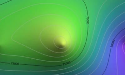
![Location of the 28 LTSER platforms in Europe on top of biogeographical regions (modified from Mirtl et al. [9]). Many more have been created in other LTER regional networks [20]. (b) Zoom in at Braila Island LTSER platform limits (yellow line) and the study area where we carried out the UAV flight (green square). (c) Zoom in at Doñana LTSER platform limits (yellow line) and the study area (red line).](http://dronebelow.com/wp-content/uploads/2019/01/drones-03-00003-g001-1024x970.jpg)
Location of the 28 LTSER platforms in Europe on top of biogeographical regions (modified from Mirtl et al.). Many more have been created in other LTER regional networks. (b) Zoom in at Braila Island LTSER platform limits (yellow line) and the study area where we carried out the UAV flight (green square). (c) Zoom in at Doñana LTSER platform limits (yellow line) and the study area (red line).
A Valuable Input That Assesses The Habitat Diversity And Wetlands Dynamics
The resulting maps are a very valuable input to assess the habitat diversity, wetlands dynamics as well as ecosystem productivity as frequently as desired by managers or scientists.
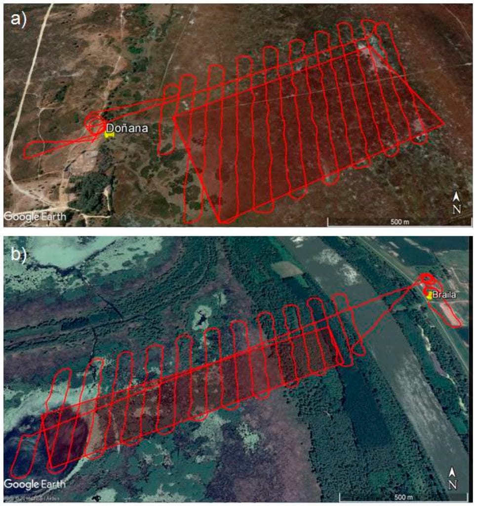
UAV flight missions at (a) Doñana marshes and (b) Small Island of Braila. Image courtesy of 2018 Google©.
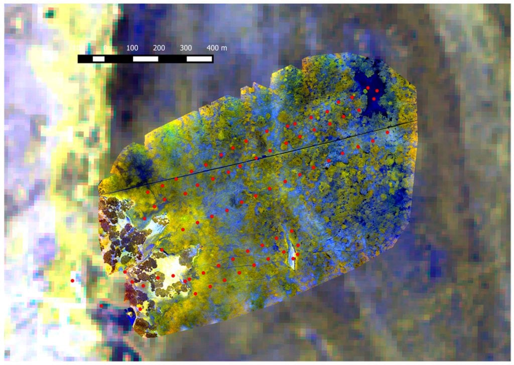
Location of ground-truth sampling points (red dots) in the Doñana study area. Background is composed by Sequoia multispectral orthomosaic on top of Sentinel-2 image equivalent wavelength composites (4-3-2 and 7-6-4).
Their patented LTSER platform also focused on monitoring the small island of Braila in the Danube River in Romania, which is known for its rich bird species. The materials and methods that the authors of this paper used include:
- Practical Remote Sensing Indicators for Rapid Ecological Integrity (EI) Assessment of Wetlands
- Multi-spectral Camera, UAV Mission Planning, and Image Processing
- Ground-Truth Sampling, Accuracy Assessment, and Remote Sensing Wetland Indicators Mapping
- Reflectance Comparison with Satellite Images
- Up-scaling of Ground-Truth Data
Results & Discussion
From the results, we can see that the work demonstrated the applicability of multispectral mapping by UAV in retrieving interesting remote sensing (RS) indicators that were relevant to assess ecological integrity (EI) in wetlands.
“Another relevant role played by UAV multispectral mapping evidenced in our work is the feasibility of enlarging the set of ground-truth data in such inaccessible or remote areas. By overflying areas where few ground points are sampled, based on spectral relationships as shown here, we can easily expand the ground-truth area to the whole flown area. Thus, we may easily increase sampling size for empirical modeling with satellite remote sensing imagery,” the authors noted.
In general, this paper confirmed the valuable and fast applicability of multispectral images captured by UAVs over two LTER wetland sites in providing detailed mapping of inundation levels, water turbidity and depth as well as aquatic plant cover.
Citation: Rapid Assessment of Ecological Integrity for LTER Wetland Sites by Using UAV Multispectral Mapping, Ricardo Díaz-Delgado, Constantin Cazacu and Mihai Adamescu, Drones 2019, 3(1), 3; doi:10.3390/drones3010003 – https://www.mdpi.com/2504-446X/3/1/3/htm