
News
Identifying Species and Monitoring Understorey Vegetation via Drone-Derived Data
Understorey vegetation is a vital part of many ecosystems. However, properly identifying it and monitoring the vegetation through remote sensing remains a challenge that many researchers and land managers have.
The emergence of unmanned aerial systems (UAS), commonly known as drones, is revolutionizing how vegetation is measured and may allow us to measure the species where traditional remote sensing previously could not.
Monitoring The Spatial: Examining How a Sensor Acquires Data in Vegetation Studies
In that manner, a team of Australian researchers have reviewed current literature to assess the current capability of drones to identify and monitor understorey vegetation – more specifically – the spatial resolution, sensitivity, extent and temporal frequency at which a sensor acquires data.
According to the researchers, there are different methods to monitor vegetation which largely depend on a couple of factors. As they state in the introduction of the paper titled, ‘Identifying Species and Monitoring Understorey from UAS-Derived Data: A Literature Review and Future Directions’:
“Methods to monitor vegetation depend on the specific goals of the research or management activities. The traditional, and most prevalent, methods involve hands-on fieldwork . However, the spatial extent at which fieldwork can be conducted is usually limited due to its high logistic cost, in terms of time, money, and site access. Therefore, field-based methods have been considered ‘impractical’ for the monitoring of large areas.”
Currently, remote sensing of vegetation has been mostly limited to monitoring the overstorey while the understorey and its contribution has been greatly overlooked at mostly because of its challenges, as the authors note.
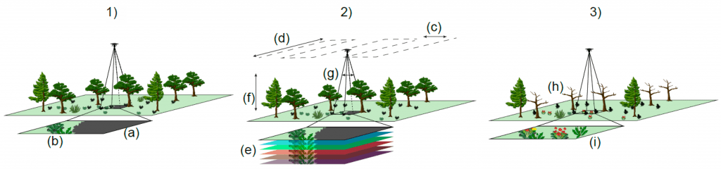
Identification and monitoring of understorey vegetation: challenges and suggestions to overcome them. (1) illustrates key challenges involved with identification and monitoring of understorey vegetation, which can be subdivided on (a) overstorey and its shadow blocking view of understorey species and (b) intrinsic challenges of understorey identification as related to scale (smaller species) and spatial and spectral overlap of understorey species. (2) Shows how flight parameters and technical specifications can be manipulated to help overcome the challenges of understorey monitoring. To overcome obscuration from the overstorey, users can (c) reduce the line spacing to increase side overlap, and (d) reduce speed to increase the forward overlap. To help overcome the spectral overlap of understorey species, (e) sensor spectral range can be increased, such as with the use of multispectral and hyperspectral sensors. To assist with the detection of small understorey plants, operators can (f) fly lower and (g) change the camera specifications by increasing sensor resolution and increasing the focal length of the lens used. (3) Shows how UAS flights can be timed to overcome overstorey obscuration and spectral overlap in the understorey. Overstorey obscuration can be overcome by (g) targeting “leaf off” periods if working in deciduous environments. Spectral overlap can be overcome by targeting understorey phenological events such as (h) senescence and (i) flowering.
UAS and Remote Sensors: Acquiring Data Through Satellite, Aerial And Terrestrial Technologies
In times when traditional remote sensing systems are failing to detect and monitor understorey species due to their limitations, UAS and remote sensors can acquire data passively or actively while detecting the reflection of the sun’s radiation.
Speaking of which, the most utilized and prevalent active sensors right now are the Light Detection and Ranging (LiDAR) sensors as well as other platforms including satellite, aerial and terrestrial technologies.
When it comes to the actual UAS, the authors stated:
“UAS exist with many shapes and flight attributes, however, they are mainly subdivided into two groups: fixed-winged (the UAS-equivalent of airplanes) and multi-rotor (the equivalent of helicopters) platforms. In order to fly, fixed-wing systems must keep moving forward and have horizontal take-off and landing requirements (with some exceptions), while multi-rotors can hover and have vertical take-off and landing capabilities. The main difference among multi-rotors is the number of rotors, which can vary between one and sixteen.”
Moreover, the authors used a systematic literature review method that involves a search of previous research and original papers published in peer-reviewed journals available online. As they displayed, the results show that there are 131 articles relevant to this subject.
After reviewing them all, the authors found that drones have made important contributions to improve spatial resolution. However, the drone-derived data is very sensitive to discrepancies in geographic positioning. Therefore, ground-truthing is an essential part of the drone-derived data and high precision Geographic Positioning Systems (GPS) can definitely be used for the aim of their research.
Final Thoughts
After addressing all of the papers and articles focused on the topics and all of the features of the technology, the authors concluded that reviewing the original research helped them to understand what successful understorey monitoring is and how it works.
“Remote sensing using UAS platforms can measure and monitor understorey vegetation at a local scale. Even though many of the limitations of passive and active sensors of traditional platforms (i.e., manned airborne and satellite) are still applicable, UAS can be successfully flown close to the vegetation and even through the foliage (although this is currently not routine), providing very-high spatial resolutions,” the authors concluded.
Aside from these as the benefits of the UAS / drone solutions, the authors also outlined the temporal frequency at which data can be acquired as a challenge that is continuously present and very flexible, usually defined by the specific needs of each project.
Citation: Identifying Species and Monitoring Understorey from UAS-Derived Data: A Literature Review and Future Directions, Lorna Hernandez-Santin, Mitchel L. Rudge, Renee E. Bartolo and Peter D. Erskine, Drones 2019, 3(1), 9; doi:10.3390/drones3010009 – https://www.mdpi.com/2504-446X/3/1/9/htm


