News
Drone Used to Map Lava Tubes in Preparation for Space Exploration
Lidar-equipped drones are now going to make space exploration feasible with high accuracy and in minimal time. In a first the SETI Institute and Astrobotic Technology, Inc. announced the successful 3D mapping of the interior of an ice-rich lava tube in Iceland by a LiDAR-equipped drone without the use of GPS or preloaded maps.
The team was investigating the Lofthellir Lava Tube Ice Cave in the remote Myvatn region of Iceland, and used the drone to document the lava tube’s shape and extent, history of rock falls, and spectacular ice formations.
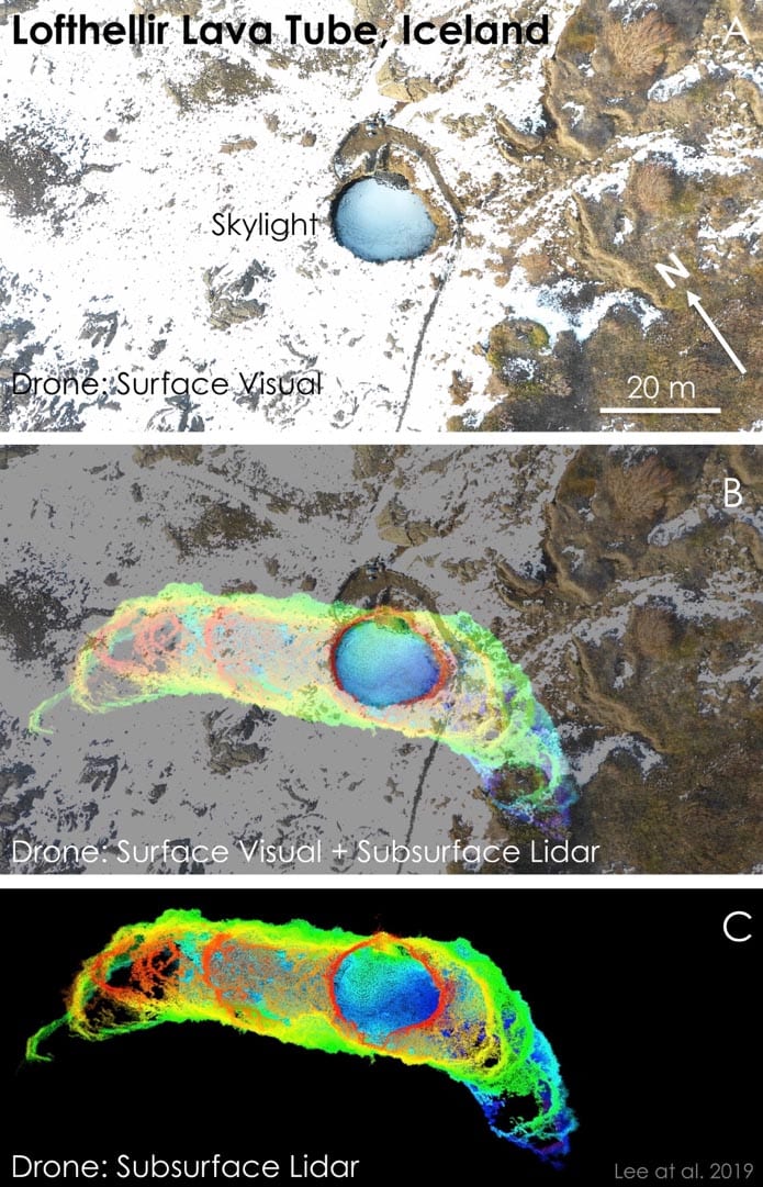
Figure 1: Drone-LiDAR mapping of the “skylight” entrance area of the Lofthellir Lava Tube Ice Cave in Iceland. Top: Aerial view of the entrance. Bottom: Drone-borne LiDAR map of the lava tube cave below the skylight entrance area. Middle: Drone LiDAR map projected against the aerial view to show underground extent of lava tube entrance area. (Credit: NASA/Astrobotic/SETI Institute/Lee et al. 2019)
Most cave openings on the Moon and on Mars are found in either volcanic terrain or terrain that was once melted as a result of intense heating from the impact of large asteroids or comets. Lava tubes form when the surface of a lava flow cools and solidifies, while molten rock underneath continues to flow and eventually drains away, resulting in a tube-shaped underground cavern.
Andrew Horchler, Director of Future Missions and Technology at Astrobotic, the private space company developing the drone-based LiDAR mapping technology says, “Small free-flying spacecraft might be the ideal robotic platform for the exploration of lava tubes on Earth, the Moon, and Mars. Nimble drones could enter, map, and exit caves quickly, returning from the darkness to send data back to Earth, return a sample to the surface, recharge and refuel.”
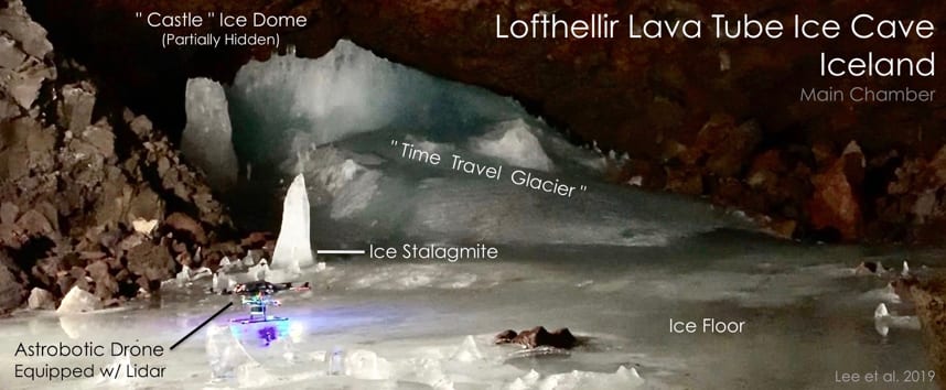
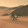
Figure 2: Astrobotic’s LiDAR-equipped drone on the floor of the Main Chamber of the Lofthellir Lava Tube Ice Cave in Iceland, ready for its subterranean mapping mission. (Credit: NASA/Astrobotic/SETI Institute/Dubai Future Foundation/Lee et al. 2019)
Caves on the Moon and Mars are expected to be targets for future robotic and human missions. In this context, the Lofthellir Lava Tube Ice is located in the same area where, 50 years ago, Apollo astronauts received a significant part of their field geology training in preparation for their voyage to the Moon.
The field team that studied the Lofthellir lava tube ice cave was led by SETI Institute planetary scientist Pascal Lee who said, “The Astrobotic drone and LiDAR performed exactly as we had hoped, and was able to help us map the Lofthellir Lava Tube in 3D within minutes. We now have a highly accurate model of the shape and dimensions of the cave, and of the configuration of its many rocky and icy features, such as rock falls, ice columns, and micro-glaciers.”
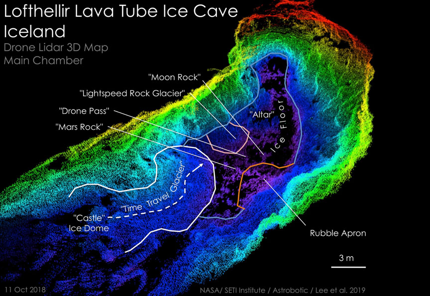
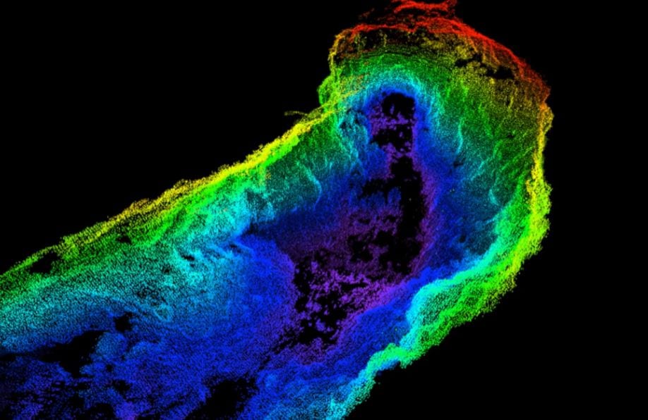
Figure 3: Drone-borne LiDAR 3D map of the Main Chamber of the Lofthellir Lava Tube Ice Cave in Iceland, with highlighted rock and ice features. Colors indicate elevation: Red is highest; Purple is lowest. (Credit: NASA/Astrobotic/SETI Institute/Lee et al. 2019).
Some adjustments will be needed while translating the technology to feasibility in lunar and Martian environments, which have thin or no atmosphere. The craft will need to be propelled by thrusters rather than propellers.
“More development work will be needed to create a system that’s ready for the Moon or Mars, but the study of this icy lava tube is an important first step for us” says Horchler.
The team is presenting the results of their study in a paper at the upcoming 50th Lunar and Planetary Science Conference convening on 18–22 March, 2019, in Houston, TX.
Astrobotic Technology, Inc. an official partner with NASA through the Lunar CATALYST Program- is a space robotics company that seeks to make space accessible to the world.
About the SETI Institute
Founded in 1984, the SETI Institute is a non-profit multi-disciplinary research and education organization whose mission is to explore, understand, and explain the origin and nature of life in the universe and the evolution of intelligence.