News
Drones and LiDAR Used to Monitor Forest Restoration Plantations
Drones and LiDAR Used to Monitor Forest Restoration Plantations
Reforestation in green zones is being carried out by ecologists’ world over. Unmanned Aerial vehicles (UAV) were used to assess the results of one such mixed-species forest restoration experiment in the Atlantic Forest of south-eastern Brazil.
- New drone system collects hundreds of forest images at different wavelengths
- Method proves efficient in forest restoration project in south-eastern Brazil
- Monitoring of large forestry areas is often done by planes and is costly
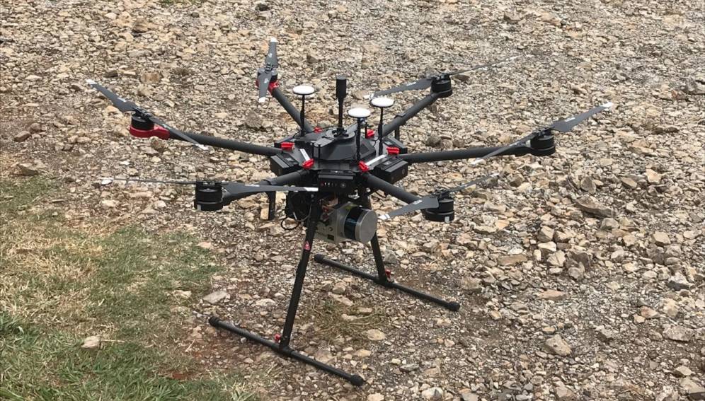
The team, including scientists from the Universities of Florida and Connecticut in the US and NASA, used a UAV-borne lidar system to collect and process forest data. The team developed a drone equipped with 3D laser scanning and hyperspectral imaging systems (the GatorEye system) capable of producing high-resolution maps and collecting hundreds of images at different wavelengths for a given area.
They measured two of the main variables used to evaluate forest structure: the height of the forest canopy and the forest biomass.
“The study’s outcomes have a huge potential of practical application and might help decision-makers to sustain public environmental policies,” Ricardo Ribeiro Rodrigues, Luiz de Queiroz College of Agriculture, University of São Paulo.
Biologist Ricardo Ribeiro Rodrigues who is at the Luiz de Queiroz College of Agriculture at the University of São Paulo, and specialist in forest recovery, spoke with SciDev.Net. He said, “The study’s outcomes have a huge potential of practical application and might help decision-makers to sustain public environmental policies. Of course, we will still need to do field monitoring”, he added, “However, this new method allows us to extrapolate the field data to larger scales, ensuring the monitoring and restoration strategies’ accuracy.”
Researchers say such data is crucial for planning new forest restoration programmes and evaluating the success of ongoing projects.
Ramon Felipe Bicudo da Silva, a biologist at the Center for Environmental Studies and Research at Brazil’s University of Campinas told SciDev.Net: “This data helps researchers to improve results of restoration projects, while also promoting the increase of native vegetation cover, and re-establishing ecological processes and environmental services once produced by forests.”
Conventionally forest structure data in restoration projects is collected by researchers on the ground which is labour-intensive and difficult for very large areas.
Researchers sometimes use aeroplanes equipped with three-dimensional laser scanning systems to cover large forest areas in a single flight, says Danilo Alves de Almeida, a forestry engineer at the Luiz de Queiroz College of Agriculture, and lead author of the study. He adds however that this is an expensive way to monitor and is reliant on companies that own aeroplanes.
Bicudo da Silva stressed that the UAV method was innovative and appeared to be feasible but requires further studies to explore the potential of the technology from an economic perspective.
The study will be published in International Journal of Applied Earth Observation and Geoinformation in July.
Citation: D.R.A. Almeida, E.N. Broadbent, A.M.A. Zambrano, B.E. Wilkinson, M.E. Ferreira, R. Chazdon, P. Meli, E.B. Gorgens, C.A. Silva, S.C. Stark, R. Valbuena, D.A. Papa, P.H.S. Brancalion, Monitoring the structure of forest restoration plantations with a drone-lidar system, International Journal of Applied Earth Observation and Geoinformation, https://doi.org/10.1016/j.jag.2019.03.014, https://www.sciencedirect.com/science/article/pii/S0303243418311954


