
News
Using Drones to Evaluate Urban Land Surface Temperatures
Using Drones to Evaluate Urban Land Surface Temperatures
Unmanned Aerial Vehicles (UAVs) or drones are now being utilized to help elucidate factors that cause land surface temperature (LST) variability in the urban environment at small spatial scales.
Urban areas across the world are experiencing thermal stresses caused by the surface urban heat island (SUHI) effect- urban land surfaces experience higher temperatures than their surrounding rural areas. The replacement of undeveloped vegetated land with anthropogenic materials that absorb more solar radiation and have different heat capacity and surface-radiation properties resulting in higher surface temperatures that pose a significant threat to human health. It is critical that the fundamental processes that drive LST are understood in order to develop solutions that can protect human and environmental health.
Thermal remote sensing is an important tool for evaluating urban land surface temperatures. Data from satellites have been used to extensively study urban land surface temperatures and their effects. However, while satellite remote sensing is valuable for evaluating LST across a city scale, the spatial resolution precludes its applications to smaller spatial scales that better reflect the spatial complexity of the urban environment. Also, satellite remote sensing is temporally constrained to intervals between 1–14 days. Aerial flights do not have the same temporal constraints but would not be economically practical on-demand temporal resolutions.
Drones are a technology that can meet this challenge. Recent advances in UAVs and radiometric thermal cameras have enabled capturing LST on-demand and at sub-meter spatial resolutions that accurately reflect the spatial complexity and detail of land surface temperatures in the urban environment. UAVs also have advantages in that they can be flown on demand to capture LST at temporal resolutions unmatched by satellite or aerial imagery.
Researchers Joseph Naughton and Walter McDonald of the Department of Civil, Construction & Environmental Engineering, Marquette University, present a study to evaluate the variability of temperatures across urban land surfaces using a drone. In this study they applied a UAV and radiometric thermal camera to capture land surface temperatures at high-resolutions (13 cm) in two case study locations.
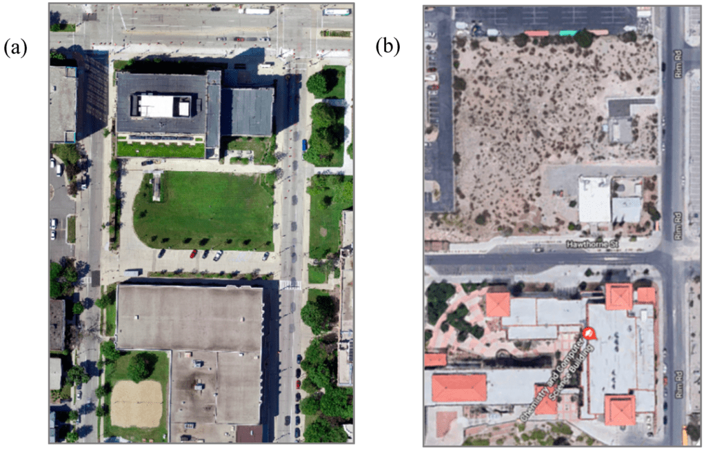
Visual imagery of the case study locations: Marquette University (a) and University of Texas El Paso (UTEP) (b). Visual imagery of Marquette was captured from a drone on 11 August 2018. Visual imagery of UTEP was pulled from Google Maps on 13 March 2019.
(1) a portion of Marquette University’s campus in Milwaukee, WI and (2) a portion University of Texas El Paso’s (UTEP) campus in El Paso, Texas. The Marquette and UTEP case study areas were roughly 21,300 m2 and 27,300 m2, respectively and included a balance of both natural landscape and impervious gray surfaces. The study included:
- Quantifying land surface temperature variability across different surface types;
- Evaluating variance in temperature across different surface types based upon meteorological and/or other derived parameters (e.g., albedo, normalized difference vegetation index, apparent thermal inertia, etc.);
- Predicting land surface temperature based upon meteorological parameters and
- Assessing diurnal variability in land surface temperature magnitude and uncertainty.
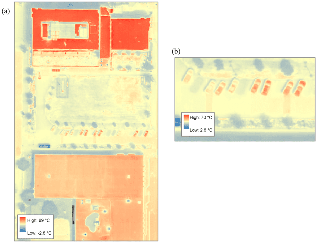
Spatial distribution of temperature from a flight recorded on 11 July 2018 (a) and zoomed in spatial distribution of temperature for the concrete parking lot from a flight recorded on 11 July 2018 (b). The hotter surfaces (red) in the right image are parked cars and the cooler surfaces (blue) are heat shadows visible after parked cars leave.
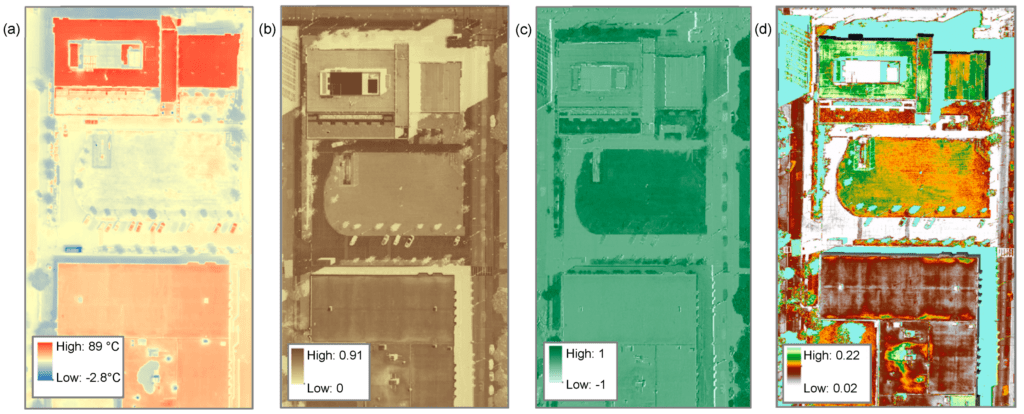
Spatial distribution of tempearture (a), albedo (b), NDVI (c) and ATI (d) for a flight recorded on 11 August 2018.
Equipment:
Remote sensing data was collected using a DJI Matrice 100 (M100) quadcopter UAV. The M100 was deployed at the case study locations with three types of camera payloads—visual, multispectral and infrared. These cameras include the DJI Zenmuse X3 visual (12 MP), Zenmuse X3 multispectral (Blue-Green-NIR 680–800 nm at 12 MP) and DJI Zenmuse XTR radiometric thermal (13 mm, 30 Hz and spectral bandwidth of 7–13 µm). Additionally, ground temperatures were validated using a Nubee NUB8380 Digital Infrared Thermometer.
Conclusions:
According to the team the results revealed that land surface temperature variability is extensive and influenced by numerous variables related to urban environments and that air temperature and solar radiation are significant predictors of mean land surface temperature. Conclusions from this study hold true in both Milwaukee, WI and El Paso, TX, indicating they could be generalized to regions beyond these two case study locations.
The key findings from this study were:
Land surface variability was significant and ranged between (3.9–15.8 °C) for common land use types.
Areas that experienced pedestrian or vehicular traffic exhibited higher variability than comparable surfaces that did not. In Milwaukee, the high-traffic road had a coefficient of variation of 0.32 as compared to 0.08 for the low-traffic parking lot. This indicates that human traffic may impact land surface temperatures due to the heat-shadow effect.
Urban geometry has an influence on land surface temperatures; shadows and reflectance from buildings showed a significant influence on the temperatures of nearby land surfaces throughout the day. Sidewalk temperatures impacted by glass reflectance were on average 4.7 °C hotter that sidewalks not impacted by reflectance.
Land surface temperature variability is low in the morning, peaks at noon and goes back down in the evening. This may indicate that as surfaces heat up, they do so at different rates, which contributes to more variability during mid-day.
Air temperature and solar radiation were significant predictors of spatially averaged surface temperature in both of our models.
Data were consistent in the models between Milwaukee, WI and El Paso, TX, suggesting that the findings in this study may be generalized beyond the case study locations.
Citation: Evaluating the Variability of Urban Land Surface Temperatures Using Drone Observations, Joseph Naughton and Walter McDonald,
Department of Civil, Construction & Environmental Engineering, Marquette University, Remote Sens. 2019, 11(14), 1722; https://doi.org/10.3390/rs11141722, https://www.mdpi.com/2072-4292/11/14/1722/htm


