News
Kongsberg Geospatial and Survae Partner to Provide Integrated Video Management Capability within IRIS GCS
April 9, 2018Kongsberg Geospatial, an Ottawa-based geospatial visualisation software company, and SURVAE, a video and data mapping technology company based in Wilmington, NC, has announced that they have integrated the Kongsberg Geospatial IRIS UAS...


AI
Into the Deep with FIFISH Underwater Drone – Interview with Belinda Zhang, Qysea Founder
April 4, 2018Qysea, a manufacturer of underwater remotely operated vehicles, has developed the FIFISH P3 to be one of the most advanced underwater drones capable of high resolution video (4K HD) and photography recording, with...


News
Drones Help Monitor Duck Hunting in Victoria
April 3, 2018The Australian State of Victoria is a popular place for the game hunting of deer, quail and duck. The industry is well regulated and controlled with generous open seasons and bag limits....
News
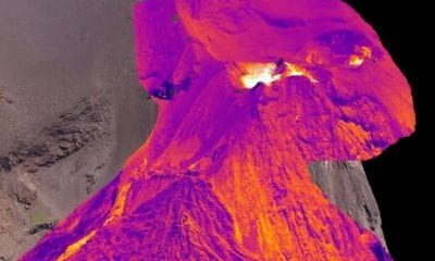
Scientists Use Drones to Create World First 3D Map of Volcano
March 30, 2018Drones have been instrumental in the creation of the world’s first 3-D thermal image of an active volcano. According to geoscientists from the University of Aberdeen, the striking image of the Stromboli...


News
‘Flying Wing’ UAV From UAVOS Soars Like a Bird
March 30, 2018Looking more like an elegant dove-inspired frisbee than a drone, the new fixed wing UAV from Silicon Valley-based drone solutions company UAVOS soars above the autumn colours of a lakeside forest. It...

