AI
How Aerial Imaging is Being Used to Help Assess Coral Reef Health
How Aerial Imaging is Being Used to Help Assess Coral Reef Health
The vast number, range and diversity of species existing beneath the ocean’s surface, along with the remote and scattered locations of reefs, presents a major challenge to scientists attempting to effectively monitor the health of such ecosystems.
Currently in order to survey a reef to identify and count species, experts must be in the water and this approach demands intensive time and resources; possibly producing unreliable results which are often difficult to compare over time.
In recent times scientists have been using images captured from satellites to identify and count species, covering a larger area with each survey; but the use of these images is limited by their low resolution.
Enter drone-mounted imaging technology. In a promising development chronicled by nature news site Mongabay, Australian researchers are trialing the use of unmanned aerial vehicles (UAVs) equipped with hyperspectral cameras to collect more detailed images and data on the health of coral reefs.
The human eye can detect a narrow range of wavelengths in the electromagnetic spectrum – the area of ‘visible light’ which, consists of three bands of energy that our eyes perceive as red, green and blue and it is the combination of these bands that an object reflects which determines the colors we see. A standard camera also captures an image recorded in these three bands of visible light.
However visible light makes up a small part of the electromagnetic spectrum; hyperspectral sensors detect energy from wavelengths across a broader range of the spectrum and are able to differentiate between materials according to the ‘ unique signature of wavelengths their surface reflects.
The images taken with a hyperspectral camera by using narrower wavelength bands cover a wider range of the electromagnetic spectrum than the three bands of visual images record and makes identifying a material possible.
While hyperspectral imaging was originally developed for mining and geology purposes, researchers are now realising the benefits of the detailed images for coral reef surveys and other environmental monitoring applications.
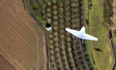
The original specialized hyperspectral camera was a very large and costly piece of equipment; Dr. Felipe Gonzalez, Associate Professor at the Queensland University of Technology (QUT), and his team have developed a miniaturized hyperspectral camera that can be carried by a UAV.
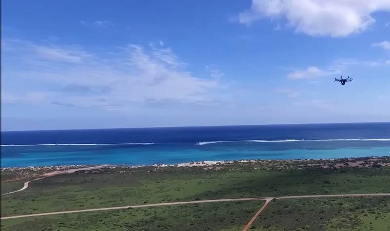
The team have carried out trials with their drone over the Ningaloo Reef, part of the world heritage coast in Western Australia, using a camera that produces hyperspectral images with a high enough spatial resolution (15 cm/pixel) to identify and monitor individual corals.
Ningaloo is one of the world’s largest fringing reefs, spanning nearly 300 km, and is well-known for the population of whale sharks that gather there to feed each year. Unlike other large reefs, such as the Great Barrier in eastern Australia, Ningaloo has been very resistant to bleaching and disease.; and in 2017 was awarded the most positive rating for ‘Conservation Outlook by the UCN World Heritage Outlook.
By having the the best technology to closely monitor the reef its health and resilience are more likely to be guaranteed for future generations.
By flying the UAV at a 100 m altitude, Gonzalez and his team are able to photograph 40 ha of Ningaloo Reef in about 30 minutes.; Gonzalez says the hyperspectral data acquired from these images enables them to “find patterns that distinguish levels of coral bleaching, water pollution, amongst others.”
The UAV makes it possible to capture images from a significantly closer distance (30-100 m from the water’s surface), resulting in high enough spatial resolution to survey the benthic composition of a reef (coral, sand, algae, etc.) and monitor the health of individual corals.
QUT’s hyperspectral camera captures the unique spectral signatures of coral, sand and algae, allowing researchers to create detailed maps of the reef habitat. The image shows the visible light spectrum, but hyperspectral imagery uses a range of wavelengths, including visible, infrared, and ultraviolet.
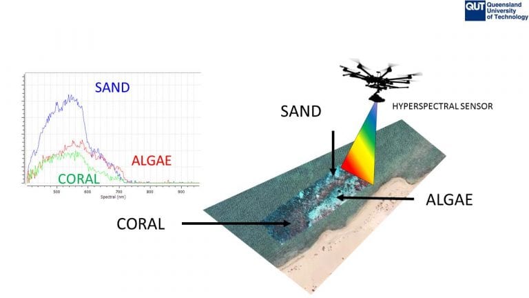
QUT’s hyperspectral camera captures the unique spectral signatures of coral, sand and algae, allowing researchers to create detailed maps of the reef habitat. The image shows the visible light spectrum, but hyperspectral imagery uses a range of wavelengths, including visible, infrared, and ultraviolet | Credit: Felipe Gonzalez
According to Gonzalez the challenge will be filtering, interpreting and computing the vast amount of data collected; he and his team are developing artificial intelligence software that will be able to differentiate coral species and predict the level of bleaching in individual corals. It also will be able to identify other features of the reef, such as sand and algae.
In contrast, other developments aimed at using the technology underwater utilize different methods of collecting data. Dr. Arjun Chennu, a research scientist at the Max Planck Institute for Marine Microbiology, recently helped to develop diver-operated equipment that captures hyperspectral images, but also measures water chemistry (pH and O2) and records the seafloor topography. The HyperDiver hyperspectral imagery enables the diver team to map benthic habitats, coral pigment densities and coral structure (rugosity) at the fine scale of a reef.
The Reefscape project uses aerial and underwater hyperspectral cameras to construct a spectral library that, when used along with satellite imaging, could make it possible to survey the coverage and health of coral reefs on a global scale.
It is presently the high cost and complex data analysis involved in hyperspectral imaging which has restricted it’s use for environmental research and conservation. However, with the popularity of the technology increasing, lower-cost hyperspectral cameras are being developed. Moreover, as artificial intelligence software for identifying spectral signatures improves, the analysis of hyperspectral data has the potential to become largely automated.

The graph shows the distinct spectral signatures of unbleached coral (Level 4, on left) and bleached coral (Level 1, on right) that are detected by the hyperspectral sensors | Credit: Felipe Gonzalez
Experts believe coral reefs have an economic value of almost $30 billion annually, $9 billion of that from tourism. However this is increasingly under threat. Coral reefs support fisheries and protect shorelines from storms but rising ocean temperatures and acidity have caused more coral bleaching; this along with pollution and sedimentation has added to the damage to reef ecosystems.
Dr Felipe Gonzalez and his team at QUT are testing the potential of hyperspectral imaging to help resource managers and policy-makers better understand how reefs are responding to these stress factors so they make more informed decisions for their long term use and conservation. This QUT Ningaloo Reef UAV project video shows how the research team uses their miniaturized hyperspectral cameras to monitor reef health. Gonzalez said his team is among the first in the world to obtain aerial hyperspectral imagery of a coral reef in such high resolution. They expect their data-gathering mission will help inform future research.