Back to Base (B2B)
Interview with Paige Cutland – Director, Unmanned Systems at Kongsberg Geospatial
Canadian company Kongsberg Geospatial have a long history of providing unmanned platforms to the military market. Having recently snapped up a contract with the Canadian government to provide situational awareness and geospatial visualisation technologies, they are now moving towards disaster response. Located amongst a plethora of other high tech companies in the Kanata Research Park of Ottawa, Ontario, their software is also used in air traffic management, control simulation and training, as well as vessel traffic management.
We spoke with Director of Unmanned Systems Paige Cutland about what Kongsberg’s role is in the unmanned space, what they bring to disaster response in Canada and BVLOS operations being undertaken in the U.S.
Can you tell us about the history / origins of Kongsberg Geospatial?
Kongsberg Geospatial is a software development company that develops geospatial and display technology for mission-critical applications. The company began by developing operator display software for Air Traffic Control displays, and later moved on to develop sensor display technology for defence applications.
The Canadian Government recently awarded the company a Drone Airspace Management contract, can you share some details on the lead-up to this, the problem it aims to address and Kongsberg’s solution?
Kongsberg has developed a touch-screen 3D display software application that provides a very easy way to interpret sensors that are scanning the airspace. The Canadian government wants to be able to quickly visualize what is occurring in the airspace surrounding an emergency event or a disaster – such as a forest fire. The government’s goal in this is twofold: they want to be forewarned if someone flies a camera drone over a disaster scene where it might be a hazard to emergency aircraft, and they want to be able to allow their own emergency personnel to safely operate observation and search-and-rescue drones in areas where other emergency aircraft are operating.

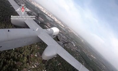
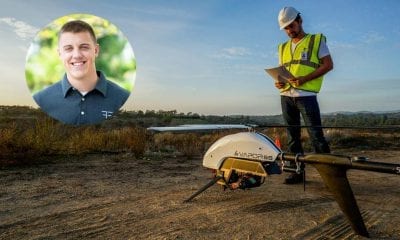
A small UAV is shown surveying the movement of a forest fire. The EOAMS would allow first responders to deploy drones at disaster scenes without endangering other emergency response aircraft or commercial flights. Photo illustration by Kongsberg Geospatial
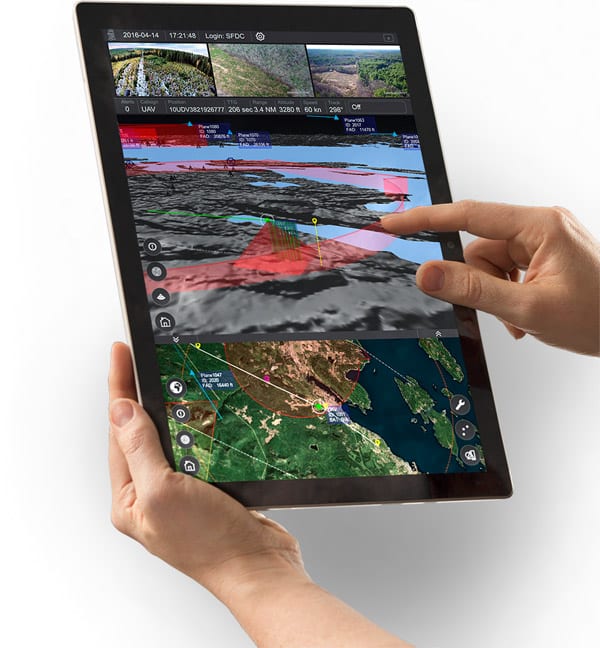
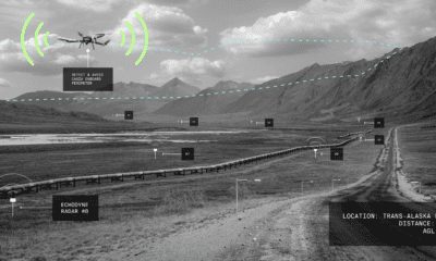
IRIS UAS is a spatial awareness system that allows UAS pilots to operate safely beyond Visual Line-of-Sight (BVLOS). The system is shown here running on a Windows Surface Pro tablet.
Can you describe how EOAMS is set up on the field, in a disaster zone?
The EOAMS sensor and display solution is transported in two medium sized cases in a single vehicle and can be unpacked, set up, and operational in under 30 minutes. The operator simply unpacks and erects the sensors, and plugs them and a touch screen display into a specially configured laptop.
In terms of securing and managing airspace around a disaster scene, how actually are unauthorized UAVs dealt with?
The initial EOAMS system will allow unauthorized UAVs to be detected and their exact position to be tracked and reported. The system will allow the EOAMS operator to steer other friendly UAVs or aircraft to keep them clear of the unauthorized UAV. The unauthorized UAV can then be tracked back to its place of landing.
The system does not include, at this time, any capabilities to intercept or disrupt the unauthorized UAV.
Do you see any potential opportunities for this system beyond disaster management, for example major public events?
As a portable and quick-to-use system this solution has a variety of applications such as public events; mobile VIP protection; or critical infrastructure protection.
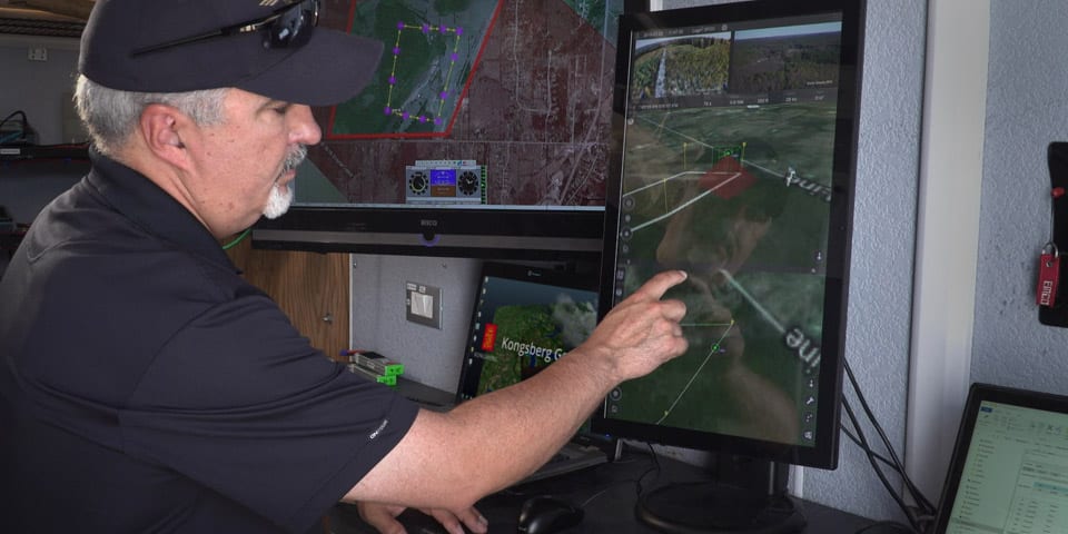
IRIS UAS program director Paige Cutland uses the IRIS UAS airspace situational awareness application to monitor the progress of a drone on a beyond line-of-sight (BVLOS) mission from a portable ground control station set up in a trailer.
Can you tell us about your IRIS UAS system and TerraLens Core?
IRIS UAS is a Ground Control Station application optimized to control UAVs that are operating beyond visual line of sight (BVLOS). It emphasizes providing the pilot with situational awareness of what is going on in the airspace around the UAV as it is operating at long distances.
TerraLens Core is the foundational geospatial platform which all of our software applications are built on.
The U.S. government recently announced the Unmanned Aircraft Systems Integration Pilot Program, how does this program impact Kongsberg Geospatial?
We have teamed up with several U.S. test ranges that have proposed pilot projects for BVLOS operations.
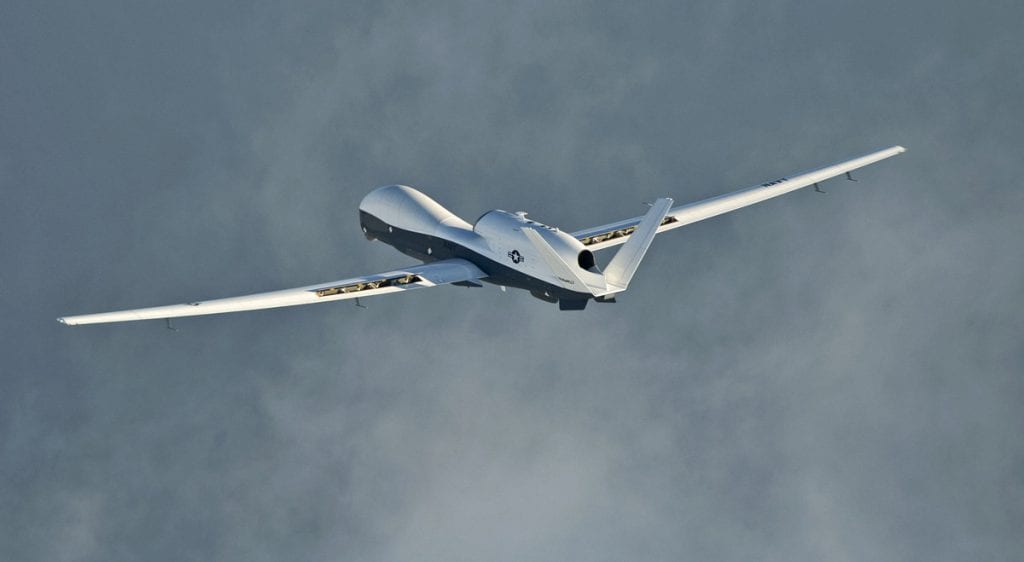
MQ-4C Triton unmanned aircraft system completes its inaugural cross-country ferry flight at Naval Air Station Patuxent River, Md. Triton took off from the Northrop Grumman Palmdale, Calif. facility Sept. 17. (U.S. Navy photo by Erik Hildebrandt/Released)
Overall how do you see the UAS/UAV technology expanding or changing in the next 5 years?
We believe that as regulators begin to enact regulations that permit BVLOS flights, the market will truly blossom. We believe more companies will adopt Remote Operations Centre business models based on increased aircraft autonomy which will permit operating multiple remote UAVs from a central location and by a single operator.
The next 20 years?
Within 20 years I think autonomous delivery services will be commonplace as will many inspection services; and that the telecommunications links will exist to permit near real-time provision of cloud analytics of the collected data.
In addition “Mobility On Demand” services will likely be common. Imagine unmanned Uber-style helicopter services available for rooftop-to-rooftop transportation in urban centres.
Anything else you’d like to add?
In the very near future, drones are going to be more autonomous, and more ubiquitous. The skies are going to become a lot more crowded – especially at low altitudes. We need to start planning now for how we’re going to manage and maintain awareness of the airspace. We’ll no longer be able to rely on the transport industry and agencies like the FAA to manage everything that’s in the air, and people who manage infrastructure will increasingly have to consider the airspace around it.
Prisons, hospitals, power plants, and stadiums and other public institutions will all have to include an airspace management strategy as part of their normal operational requirements.
About Paige Cutland
 Paige Cutland was appointed Director, Unmanned Systems for Kongsberg Geospatial in August 2014. Paige has been in progressively senior roles with industry since retiring from the Canadian Air Force as a Major in 2000.
Paige flew on the Canadian CP-140 ASW aircraft as a Tactical Coordinator and Mission Crew Commander. His last posting was to Air Strategic Plans formulating the initial RCAF requirements for the “JUSTAS” strategic UAS capability.
Paige joined industry in a project management role and has been directly involved in UAS program delivery and sales to various Federal government departments for over 15 years.
Paige is a graduate of the University of Manitoba (B.A. in Political Science) and the University of Ottawa (MBA).