Researchers Capture Canada’s Rich Biodiversity with Help of Drones
A group of researchers from Canada are taking flight with drones to discover the riches of the country’s biodiversity.
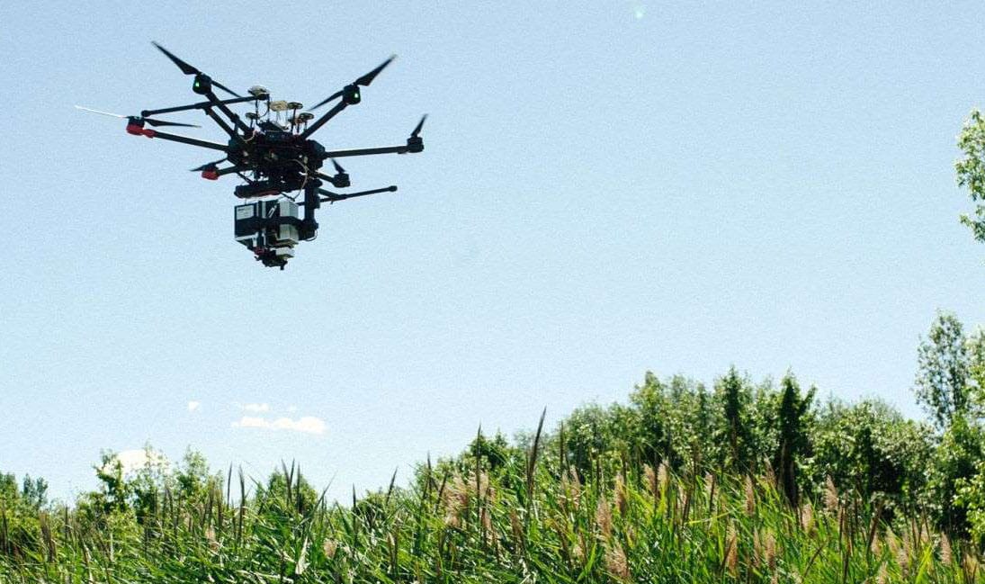
In the middle of a field on an island in the Îles-de-Boucherville National Park, Margaret Kalacska, researcher and professor at McGill University, Department of Geography, polishes the lens of an imposing hyperspectral camera.
Capable of capturing the different wavelengths, she intends to use it – and the drone it will be carried by – not for creativity, but science.
“With this camera, we will be able to photograph biodiversity from the sky,” says the researcher.
This state-of-the-art equipment will not just be used to make beautiful aerial photographs, but rather to build the first spectral code plant database in Canada.
Ultimately, these data will be used to assess the adverse effects of climate change and the impact of human activities on the flora.
A revolutionary technique
The project, led by a team of Canadian researchers, was borne from an observation by Étienne Laliberté, a professor of biology at the University of Montréal. According to him, biologists are not equipped to study rapid and profound changes in biodiversity.
“Spectranomics – remote sensing allowing the acquisition of information on a non-contact object by spectral waves – presented itself as a fast and efficient technology to follow the evolution of the ecosystem”, he says.
Using the drone removes the time consuming task of walking to identify each plant, and spectranomics offers researchers an overview of vegetation in a few drone flights.
“Each pixel of the images obtained contains 9 square centimeters on the ground,” Ms. Kalacska illustrates.
“Spectranomics makes it possible to obtain the different wavelengths reflected by the leaves thanks to sunlight,” explains the specialist in satellite and aerial imagery.
These wavelengths, exploited with sufficient precision, make it possible to identify a unique spectral signature for each plant that will be recorded.
“With the signature data, we can know what kind of plant we are dealing with, but we can also determine the effects of the environment on it,” says Ms. Kalacska.
Ranging from infrared to ultraviolet, the hyperspectral camera captures 288 wave layers – compared to three layers for our cameras that capture red, green and blue.
Research locations
“If we had the opportunity, we would map all of Canada!” the researcher laughs. For the time being, researchers have had to select Canadian heritage sites that are at risk from anthropogenic or climatic effects.
“Like the rest of Quebec, the Boucherville Islands are invaded by the common reed. Our main mission on this site is therefore to identify young shoots to eradicate them effectively “, explains Laliberté. This reed, which is often seen on roadsides, is of concern to researchers, as it is one of the invasive alien species considered to be one of the top five causes of global biodiversity loss.
As a secondary purpose, “we want to see how species regenerate on land that has been cultivated,” adds Kalacska. Agriculture, predominant on these islands about fifteen years ago, left many undeveloped lands.
Canada, a pioneer in research
The technique of spectranomics is recent in the field of biology – previously only used in geology – and attracts researchers from around the world. Seven universities, including the United States, Finland and the Netherlands, are collaborating on the Canadian project.
“Other countries would like to replicate this approach at home,” says Kalacska. I have seen the use of the hyperspectral camera on aircraft in the United States, but I have never seen it on drones,” she says.
The research group, which received a $CAD4 million scholarship from the Natural Sciences and Engineering Research Council of Canada, is working on new camera prototypes suitable for aircraft or satellites. “With new cameras on satellites, we will be able to visualize the evolution of biodiversity in real time with greater accuracy,” explains the professor.
Collaboration
The project mobilizes many students to gain know-how in the field of biology.
“It’s an amazing experience for them,” enthuses the researcher in geography.
In the spirit of collaboration, the data obtained by Canadian researchers will be made public.
“In our research, we have specific questions. But all this data collected can be used by other people for different purposes, “she says.
It will be necessary to be patient before being able to access the results of the researchers; they will appear this winter.
After traveling through British Columbia and Ontario, researchers will continue to Mount Megantic and the Yukon in the coming weeks.
A version of this story first appeared in French on Des Devoir.


