News
Using Wireless Drones with Google’s Earth Simulator: Is it Possible?
Nowadays, unmanned aerial vehicles (UAVs) or drones, are getting significant attention in a number of industries. Drones are not only here to ‘fly around’ – they are actually here as an approach that lets us enhance the wireless communication performance. When paired with the right hardware and cellular infrastructure, these drones can have a magnitude of possibilities.
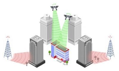
Wireless Drones Can Help a Range of Emergency Scenarios
One of these possibilities is the Line-of-Sight (LoS) link with users, which ensures optimal connection strength. Coupled with the reliability and autonomy of drones, this advantage gives attractive qualities to service providers which is why drones can help a range of emergency scenarios such as disaster relief etc.
Aside from this, UAVs can also be used to complement the existing terrestrial cellular systems – all thanks to their increased capacity for crowded areas during temporary events. They can be deployed to provide wireless connectivity to rural areas in which the presence of large-scale ground wireless infrastructure is also limited.
Connecting Each Piece of The Puzzle
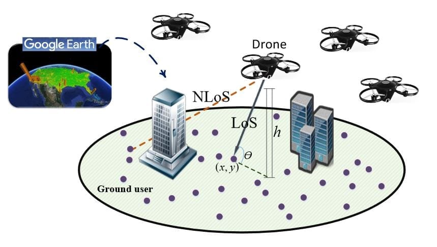
However, drones require proper networking applications in order to be effectively deployed. There must be an efficient with potential use-case scenarios and ground environments. Even though many simulators have already been tried, only some have been used for the analysis of three-dimensional and ad-hoc networks – such as the ones that Google Earth requires.
Still, while there has been a lot of notable work on UAV deployment, all of the work does not consider the potential use of the geographical information for optimal placement of these wireless UAVs. Whether it’s altitude or a probabilistic path loss model, a lot of the problems are associated with the minimum number of drone base stations.
At the same time, a drone base station is more than just needed – to be able to process the images in Google Earth Engine and deploy them from specific locations – but also be able to maximize the wireless connectivity in various scenarios (as a result).
A Paper Aims on Revolutionizing Wireless Connectivity Through UAVs (Drones)
A paper published online at the Virginia Tech by Aaron French, Mohammad Mozaffari, Abdelrahman Eldosouky and Walid Saad talks and aims at the development of a framework for environment-aware deployment of multiple drone base stations which provide wireless connectivity for ground users. Named “Environment-Aware Deployment of Wireless Drones Base Stations with Google Earth Simulator”, the framework will exploit geographical information extracted from the Google Earth Engine – and determine the locations of buildings that disrupt LoS.
System model for drones’ deployment
The paper carefully reads each of the steps that will be summed up for the creation of the system:
“First, we study the optimal placement of drones for maximizing the number of covered ground users. In the second scenario, we aim to provide full coverage for ground users by using a minimum number of drones. Finally, given the load requirements of users, we analyze the optimal deployment of drones for which the total flight time of drones needed to service the users is minimized. Simulation results reveal that our proposed framework that exploit buildings’ information on an area in Virginia Tech’s campus using Google Earth yields a significant improvement in the coverage and energy efficiency of the drone-enabled wireless networks.”
As such, the framework gives a rough roadmap which is later explained in steps, with fractions and in-depth analysis throughout the paper.

Results of building identification imposed over satellite imagery for a region of the Virginia Tech campus
A Model That Needs its Theory Put to Practice
While this may be a possible model of environment-aware deployment of drone base stations that provide wireless connectivity to ground users, it still needs a lot of work – and a lot of theory put to practice.
To this end, the authors of the paper have developed a drone network simulator that uses the Google Earth Engine in order to extract the key information about buildings in the considered geographical areas – as well as minimized the flight time of drones to completely service the users to satisfy their load requirements.
Source: https://arxiv.org/pdf/1805.10424v1.pdf