Defense
Finding Crashed Drones Based on Machine Intelligence and IoT
Occasionally planes and helicopters vanish without a trace; more often than not when aircraft are flying over remote regions or oceans. The challenge in these instances is to identify the location of the aircraft and retrieving them, or at least what is left of them.
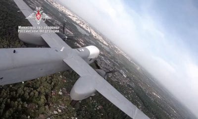
Drones are prone to crashes even more than helicopters and airplanes and their retrieval is often problematic and of course extremely annoying for people who use drones for entertainment and recreation. However, the same problem could be catastrophic for potential systems running units of Unmanned Aerial Vehicles (UAVs) for applications like delivery of medicine in emergency situations, military operations, carrying expensive packages etc.
To address the issue of retrieving drones after they crash, ‘The Effective Recycling Of Crashed Drone Based On Machine Intelligence‘ was published by the Chinese scholars, Jun Yang, Jiayi Lu, Yiming Miao, Lu Wang, Yiting Zhao and Yong Cao as they acknowledge the problem, its multiple possible solutions with their comparisons and their own potential optimal solution.
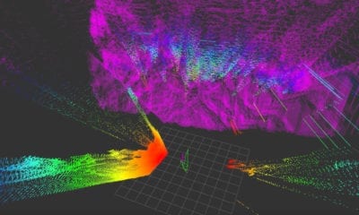
The researchers used a machine learning algorithm to assess the accuracy of drone crash site in the complex scene, and make the data statistics and test in combination with the true scene. They did not only identify the location of the crash, but also put forward programs for extracting the said location and formulating means to search and recycle the drone.
Tracking and data communication: Currently, the most commonly used means of knowing the location of an aircraft at any instance is to use GPS (Global Positioning System) and communicate the location via 2G, 3G or 4G internet. The serious problem with this method of tracking anything, let alone a drone, is that steady 2G, 3G or 4G signals are not available everywhere, making the location recorded by the GPS practically useless in terms of tracking the drone down. The limitation of territory can be catastrophic.
The researchers, for the reason stated above, preferred using Internet of Things (IoT) to break through the problem posed by limitation of territory. IoT solutions require less power for data communication and are more effective in practice. The icing on the cake would be that the drone does not only communicate its location, it can be configured or programmed to communicate anything; the video it is capturing, the state of its components and most importantly, what damage it has taken or absorbed. Citing the paper itself: “IoT technology enables the destroyed drone to send the current GPS information (GPS system navigated from the aircraft itself, or wireless system combining IoT and GPS), and meanwhile the drone can report the current system state (such as wing damage and motor damage), so that the manipulator judges whether recycling is feasible economically.”
So essentially, with IoT, we are not only tracking the location of the drone more effectively, but we are also tracking the damage it has taken.
As a backup communication plan, the researchers propose the usage of an entire Unmanned Aerial System (UAS) compiled of multiple drones. Why? Because multiple drones even large distances apart from each other can largely expand the range of the signal transmitted by each of them, allowing smooth data communication even in areas where IoT network is not conveniently working.
Searching of drones: Rescue operations for crashed drones are best performed by other drones that due to the data communicated by the crashed drones, are likely aware of any aberrant circumstances that caused the crash. The rescue drones, after reaching the region of crash, scatter through the region with defined coordinates in space. Each of them formulates their individual coordinates defining their own area of scouting and after searching their respective regions, individual drones stop searching or scouting. The operator of the drones is required to define the search area for the entire drone cluster used for searching, the programmed algorithm then takes on and distributes regions to individual drones.
Recovery: The Data Center receives the notification transmitted by the crashed drone in real-time, after which the server decodes the information sent by the crashed drone; its location and its status. Afterwards, the search and rescue team moves to the location of the crash for recycling the drone as per the GPS information received. If the location is inaccessible or the rescue team fails to discover the crashed drone, they will launch the searching drone, and search around the targeted GPS. The searching drone being more effective than a team of people, will report the precise location of the crashed drone and record pictures of it so that it can be recovered.
Citation: Technologies for Efficient Amateur Drone Detection in 5G Millimeter-Wave Cellular Infrastructure, Dmitrii Solomitckii ; Margarita Gapeyenko ; Vasilii Semkin ; Sergey Andreev ; Yevgeni Koucheryavy, Article in IEEE Communications Magazine 56(1):43-50 | DOI: 10.1109/MCOM.2017.1700450 | https://ieeexplore.ieee.org/document/8255736/ |