News
Water Sampling Using Drones in Japan
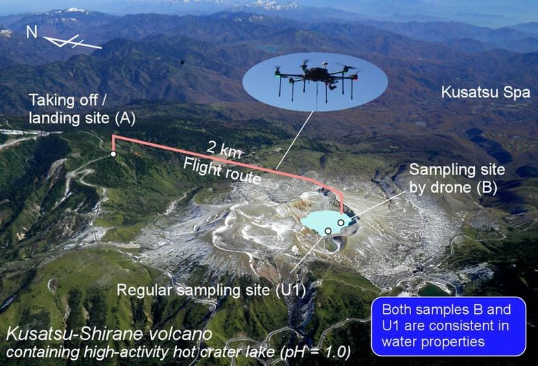
In a new attempt to make most of water sampling, a group of authors have submitted an express letter in which they detail the performance of their remote sampling of water from the Yugama crater lake at the Kusatsu-Shirane volcano in Japan.
The aim of the procedure was clear – to follow who operates a drone without additional special apparatus and compare the lake water sampled by drone with that sampled by hand at a site where the regular samplings have previously been carried out. The chemical concentrations and stable isotope ratios are largely consistent between the two techniques.
Since the drone can fly automatically with the aid of navigation by Global Navigation Satellite System (GNSS), it is entirely possible for it to repeatedly sample lake water from the same location, even when the entry to the crater is restricted due to the risk of eruption.
Regular Water Sampling and Water Chemistry Analysis: The Most Straightforward And Valuable Methods For Early Warning Of An Eruption
As we mentioned earlier, the authors of this paper focus on finding the most valuable methods for early warning of an eruption. Before detailing the complete methodology, they are confident that drone systems are the perfect way to provide warning about potential eruptions and inform the public.
“When intensive earthquake swarms or small explosions are detected, the volcano alert level is set to 2 or 3 to provide warning and inform the public. Under such conditions, entry is not permitted to the summit area of Kusatsu-Shirane volcano. Although sampling of the lake water is important for monitoring purposes, it is hampered by the difficulty in accessing Yugama crater lake during high alert levels.”
The authors also point out to the fact that unmanned aerial vehicles (UAVs) have been utilized at many volcanoes in order to measure the components in volcanic gas as well as the ground surface temperature and the magnetic field in the 3D modelling of the terrain.
Their outline of the Kusatsu-Shirane volcano and the complete methodology uses a drone to sample the lake water from the crater lake, a sampling device (metal-free bottle made of high-density polyethylene) for sampling as well as a couple of sampling procedures.
They also noted the challenges, mentioning that “there are some limitations to this approach. The camera view transmitted from the drone is unlikely to provide sufficient information for the operator to estimate an accurate relative height between the drone and the lake surface.”
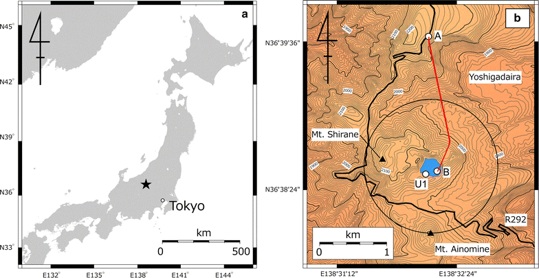
Location and topography of Kusatsu-Shirane volcano. a Location map of Kusatsu-Shirane volcano within Japan (marked by a star). b Topographic map of Kusatsu-Shirane volcano. Solid lines are topographic contours at intervals of 10 m. “A” and “B” correspond to the takeoff/landing site and water sampling site, respectively. Regular sampling of lake water by hand has been carried out at site U1. Red line indicates the flight route for water sampling on October 18, 2017. The circle indicates a distance of 1 km from the center of Yugama crater lake
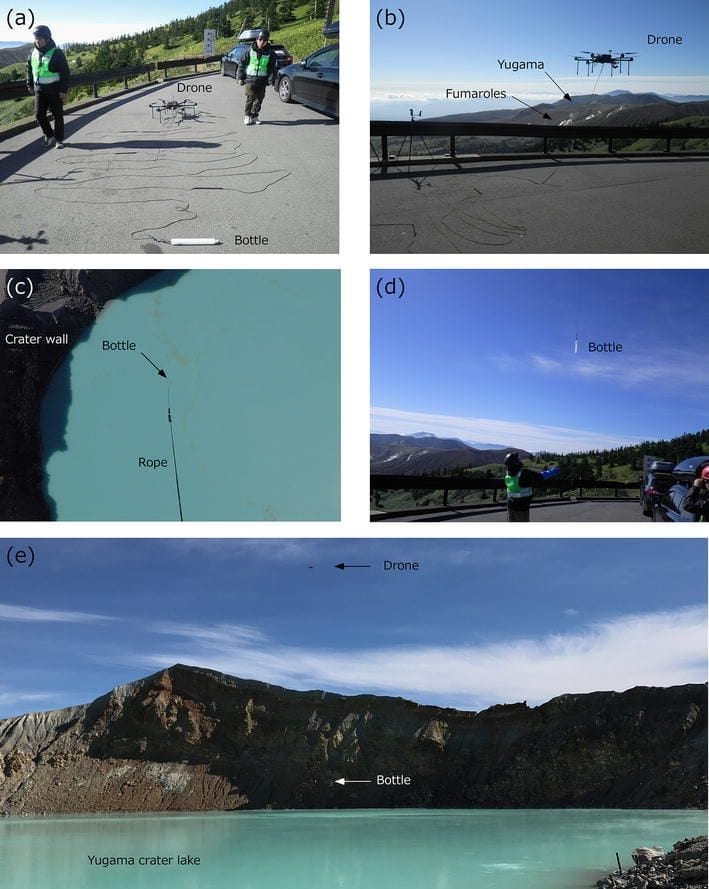
Photographs of the drone operation on October 18, 2017. a Setup of the drone LAB645, with the rope and sampling bottle on the ground. b Taking off with the suspended sampling bottle. c Photograph above sampling point B shown in Fig. 1, taken by a camera on the drone. d Catching the bottle by hand just before landing. e Approach of the drone and sampling bottle to the surface of Yugama crater lake
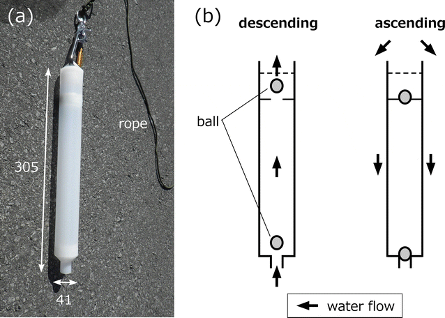
Photograph and schematic illustrations of the water sampling bottle. a Photograph of the water sampling bottle, and b schematic illustrations of the bottle. Numbers in panel a represent dimensions in millimeters
The Results Of The Survey (Water Sampling, Discussion And Conclusion)
The height of the sampling waypoint was altered and according to the laser range finder observation undertaken by an observer of the lakeshore, the authors found that the drone successfully sampled more than 250 ml. Of water from the Yugama crater lake during a calm period at the Kusatsu-Shirane volcano.
“Using programmed waypoints, the drone can repeatedly sample lake water at exactly the same location, even during periods of high probability of volcanic unrest (when approaching Yugama crater lake is prohibited by the local government). Sampling locations and depths can be easily altered by modifying the waypoints, and therefore, other features of interest can be sampled (e.g., fluid emissions from subaqueous fumaroles),” the authors concluded.
The authors also stated that the procedure of water sampling presented in their paper is “robust and easy to achieve” and can be therefore carried out by many volcanologists using only a drone without any special apparatus or techniques. If the drone can carry a load of multiple bottles, simultaneous water samplings “may be possible,” according to the authors.
At the Yugama crater lake, the authors found that interaction between groundwater and degassing magma is a possible mechanism of temporal change in the ratio of the lake water – a process controlled by the breaching of a self-sealed zone.
The author’s research and procedure can certainly serve as a framework for future studies – and especially a future technology used by volcanologists worldwide.
Citation: Water sampling using a drone at Yugama crater lake, Kusatsu-Shirane volcano, Japan, Akihiko Terada, Yuichi Morita, Takeshi Hashimoto, Toshiya Mori, Takeshi Ohba, Muga Yaguchi and Wataru Kanda, Earth, Planets and Space201870:64, https://doi.org/10.1186/s40623-018-0835-3


