News
Monitoring Breeding Waterbirds with Drones
Currently, waterbird communities are seen as potential indicators of ecological changes in today’s threatened wetland ecosystems. Because of that, they are often seen as a potential object of ecological monitoring programs.
Right now, waterbirds often breed in largely inaccessible colonies in flooded habitats. Therefore, one of the best forms of surveying is through the use of unmanned aerial vehicles (UAVs) as a robust method for estimating their breeding population size. In fact, UAVs can help counts of breeding pairs to be carried out by both manual and automated detection routines.
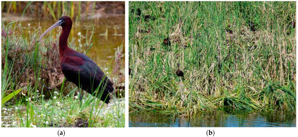
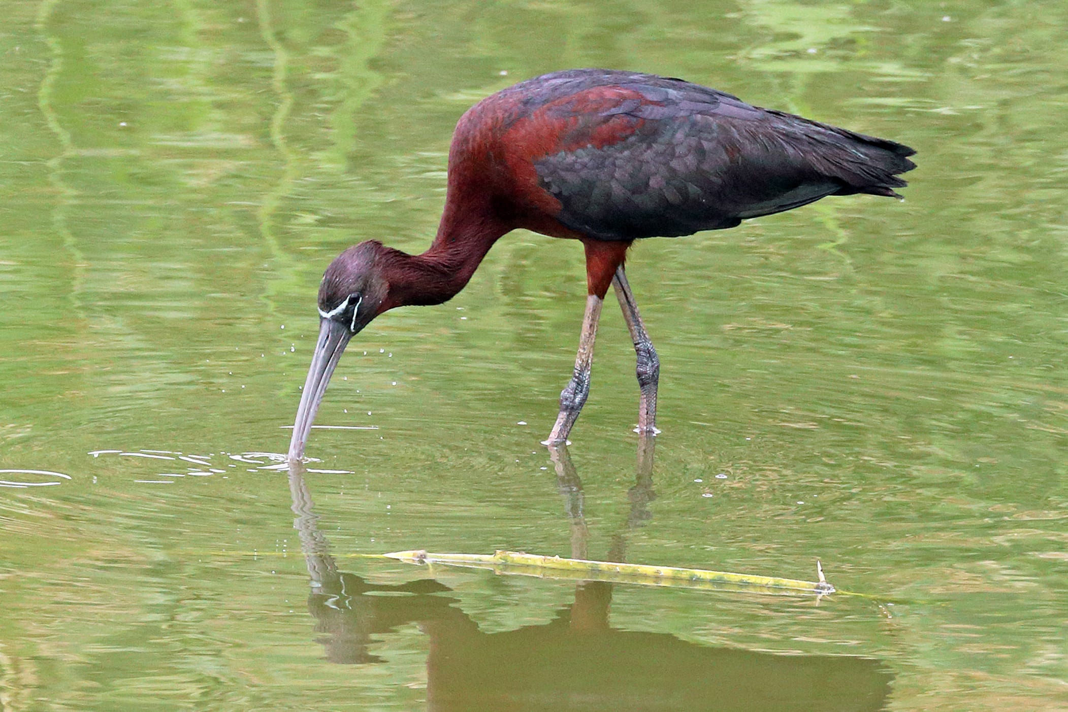
(a) Glossy ibis (Plegadis falcinellus) individual. (b) Front view of the Glossy ibis colony, densely covered by the macrophyte Typha, which makes it extremely difficult the ground census of the colony. Photos: Carlos Gutiérrez-Expósito (a), and Manuel Máñez (b).
Examining the Breeding Colony of Glossy Ibis Waterbirds
One study aims to survey the main breeding colony of Glossy Ibis at the Doñana National Park (SW Spain) and show that UAVs are an effective method for obtaining a high resolution image and visually interpreting everything by an expert.
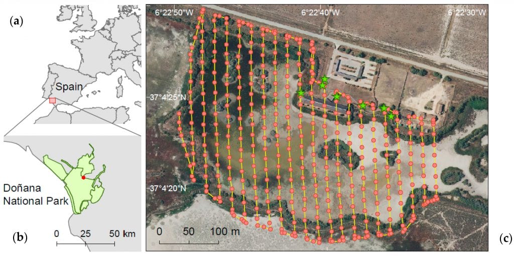
Figure 2. Location of Doñana National Park, SW Spain (a,b). Red dots indicate the situation of the Glossy ibis colony. (c) Automatic flight path covered by the UAV to collect image of the Glossy ibis colony in “Lucio de la FAO”. The UAV followed 22 predefined transect lines (yellow lines, 6292.2 m) with 80% front overlap and 70% side overlap. Green stars show ground control points (GCPs) established to increase the absolute global accuracy of drone image.
The authors of this study suggest a standardized methodology for nest counts that would be repeatable across time in order to ensure a solid long-term monitoring census through a supervised classification based on the spectral properties of the image and a subsequent automatic size and form based count.
Still, the authors also point out the potential challenges of their project, noting the following:
“Despite the fine spatial resolution data that UAVs can deliver, there is some bias inherent in this methodology that could hamper the extraction of accurate population data of densely colonial aggregations of birds: the absence of ground-truth data in inaccessible habitats, the difficulty of isolating and quantifying individuals or nests because of their cryptic nature or poor visibility through the canopy and the potential negative interactions between bird and drones. Furthermore, the quality of sensors is rapidly increasing, resulting in progressively very large images which are difficult to treat with standard image processing software.”
Evaluating the UAV Capabilities to Perform Aerial Censuses
The main purpose of the study is to evaluate the capabilities of UAVs to perform aerial censuses of densely populated wetland colonies of waterbirds – with an aim of integrating UAV flights in the long-term bird population monitoring.
The authors used various materials and methods to conduct the study in the Doñana wetlands which are known as breeding grounds for many birds including the Glossy Ibis. They used the “Lucio de la FAO” system which consists of three interconnected semi-artificial ponds covering a total surface area of about 50 hectars, flooded by both direct precipitation and groundwater pumped from the underlying aquifer.
“The UAV followed an automatic flight programmed beforehand with 22 transect lines covering an area of 16.1 ha with 80% front overlap and 70% side overlap (see Figure 2). The flight settings were defined using Pix4DCapture mobile app (Pix4D SA). The drone was flown at an altitude of 50 m above ground elevation and at a ground speed of 12 km h−1. A total of 448 images were taken.”
The Inability to Collect Ground-Truth Data
One of the challenges was the inability to collect ground-truth data for several of the nesting birds in the colony. That is why the authors performed a manual and visual identification of the breeding birds in the orthomosaic.
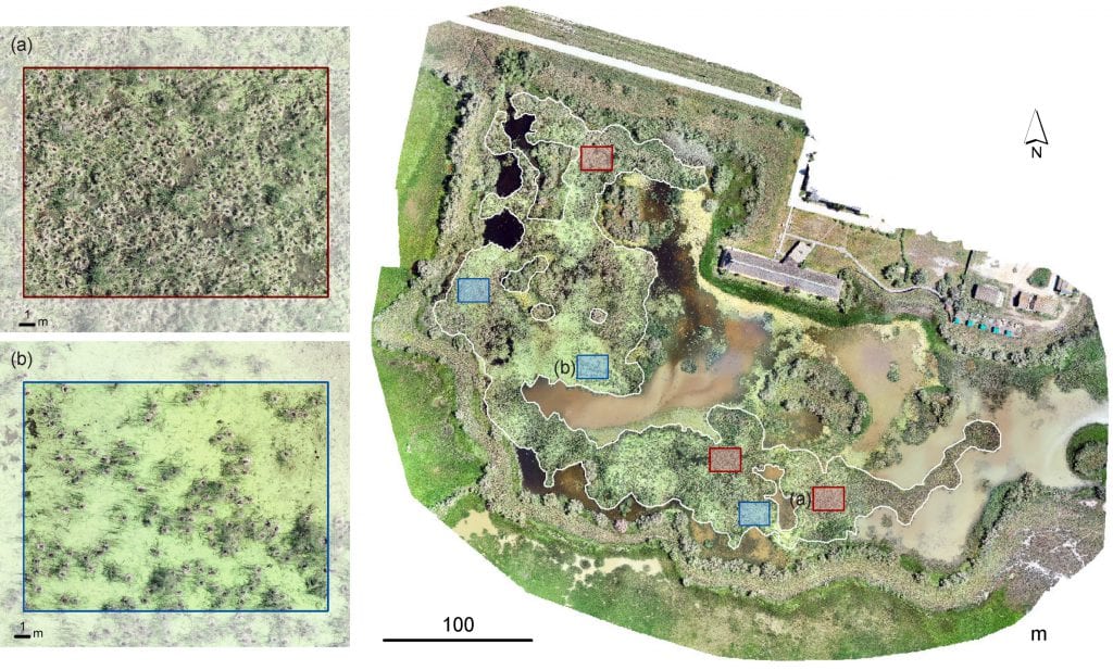
Orthomosaic image of high-resolution of the Glossy ibis colony in “Lucio de la FAO”. Image was mosaicked with Pix4D mapper Pro (Pix4D, Switzerland) after acquiring 448 photos through automatic flight of Phantom 4 Pro quadcopter (DJI Innovations, Shenzhen, China) on 14 May 2018. Squares show validation areas to test the accuracy of the automatic nest counting method to the visually nest count by an expert. Blue squares show densely macrophytes area (Typha spp) whereas red squares showfree areas of emergent vegetation covered by Lemna aquatic plant. White line delineates the Glossy ibis nesting area.
The automatic identification of breeding individuals was accomplished in two steps:
“First we performed a supervised classification based primarily on the spectral properties of the image with the aim of simplifying the original complexity of the entire scene and enhancing the subsequent automatic detection of Glossy ibis individuals. In a second stage, we carried out an automatic count using image processing software where size and form were introduced to the recognition process.”
After processing the images and validating the results and their accuracy, the authors have come to a conclusion that overviews their entire project.
Conclusion
As the authors originally put it in the paper, the study conducted with the help of UAVs allowed them to obtain a high-resolution image of the main Glossy Ibis colony in the Doñana National Park – through which they determined the nests established, their spatial location as well as the presence of other species breeding in sympatry with the Glossy Ibis.
“While an improvement of the spatial and radiometric resolution of the image may provide a better outcome, we propose here a methodology that allows a standardized automatic nesting count, easily implementable and repeatable across time for long-term monitoring censuses.”
With this, the authors confirmed the UAV capability for detailed monitoring of Glossy Ibis (and other waterbirds). However, they also pointed out that as the capabilities of UAVs increase in terms of flight endurance and sensor resolution, a larger amount of high-resolution data will be collected, making the automatic processing a common need in monitoring.
Citation: Drone Monitoring of Breeding Waterbird Populations: The Case of the Glossy Ibis, Isabel Afán 1, Manuel Máñez and Ricardo Díaz-Delgado, Drones 2018, 2(4), 42; https://doi.org/10.3390/drones2040042


