![(a) Location of the 16 first Long-Term Socio-Ecological Research (LTSER) platforms declared in 2007 in Long-Term Ecological Research (LTER)-Europe [34] plus the three incorporated in 2010. Nowadays, the number has increased to 31 [35] and more have been created in other LTER regional networks [36]. (b) Location of Kiskun LTSER platform in Hungary (green area) and the ExDRain experiment site (red dot). (c) Details of experimental area with the different treatment plots. (d) Plot size and treatment legend by colours and crosses.](https://dronebelow.com/wp-content/uploads/2019/01/drones-03-00007-g001.jpg)
News
Enhancing Ecological Field Experiments by Using Multispectral Sensing via Drone
Although many climate research experiments are providing valuable data, long-term measurements are not always affordable. Over the last decades, several facilities have secured long-term experiments, but few studies have incorporated spatial and scale effects. Most of them have been implemented in experimental agricultural fields but none for ecological studies.
This is why a group of researchers are focusing on scale effects, assessing the use of remote sensing images from space or airborne platforms such as drones or unmanned aerial vehicles (UAVs).
In this paper the researchers assess the applicability of UAV-borne multispectral images to provide complementary experimental data collected at point scale (field sampling) in a long-term rain manipulation experiment located at the Kiskun Long-Term Socio-Ecological Research (LTSER) site named ExDRain to assess the effects on grassland vegetation.
Assessing the Applicability of UAV-Borne Multispectral Images Providing Experimental Data
“In this work we assess the applicability of UAV-borne multispectral and RGB (Red-Green-Blue) cameras to enhance experimental data by providing complementary information. We check the correlation between data collected at point (field sampling) and plot (UAV sampling) scales and analyse new observed patterns in relation to the effects of the ExDRain experiment on the vegetation. We question whether NDVI-derived from UAV multispectral images acquired at lower scale are in coherence with Cropscan point measurements. On the other hand, we examine the information provided by UAV images and assess the effects of experimental treatments at plot scale, by which we hypothesize that effects at different scales may be different and can enhance the interpretation of the observed results,” the authors said.
The team made use of a DJI Phantom 4+ quadcopter equipped with its original 4K 20 megapixel CMOS camera and a Parrot Sequioa with a special camera mount, capturing images at 4 spectral bands.
![(a) Location of the 16 first Long-Term Socio-Ecological Research (LTSER) platforms declared in 2007 in Long-Term Ecological Research (LTER)-Europe [34] plus the three incorporated in 2010. Nowadays, the number has increased to 31 [35] and more have been created in other LTER regional networks [36]. (b) Location of Kiskun LTSER platform in Hungary (green area) and the ExDRain experiment site (red dot). (c) Details of experimental area with the different treatment plots. (d) Plot size and treatment legend by colours and crosses.](http://dronebelow.com/wp-content/uploads/2019/01/drones-03-00007-g001-1024x721.jpg)
(a) Location of the 16 first Long-Term Socio-Ecological Research (LTSER) platforms declared in 2007 in Long-Term Ecological Research (LTER)-Europe [34] plus the three incorporated in 2010. Nowadays, the number has increased to 31 [35] and more have been created in other LTER regional networks [36]. (b) Location of Kiskun LTSER platform in Hungary (green area) and the ExDRain experiment site (red dot). (c) Details of experimental area with the different treatment plots. (d) Plot size and treatment legend by colours and crosses.
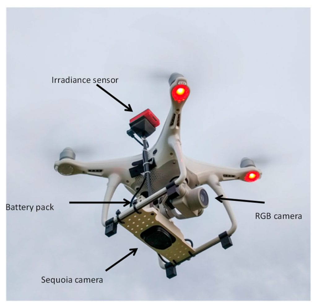
Unmanned Aerial Vehicle used for the study consisting of a DJI Phantom 4+ quadcopter equipped with its 4K RGB camera and a specific mount for the Parrot Sequoia multispectral camera, including both the camera itself and the sunshine sensor (original design from Zcopters).
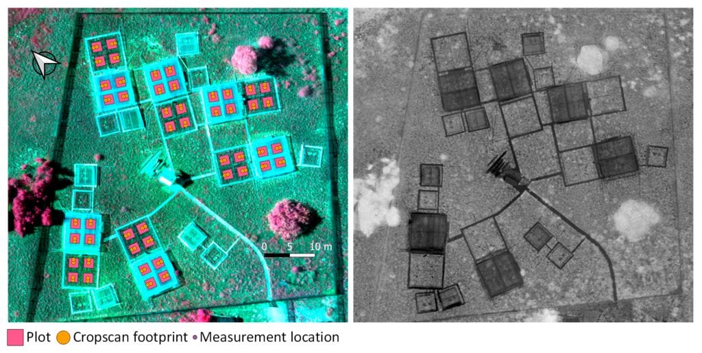
Left image shows a false color RGB composite with near infrared-red edge-red Sequoia bands with the overlay of plot limits, Cropscan sampling footprints and measurement location points. Right image shows Normalized Difference Vegetation Index (NDVI) image calculated with Sequoia near infrared and red bands evidencing the plots covered by plastic (darker plots).
Precision Testing & Parallel Ground Measurements During UAV Flights
The authors also focus on precision testing as well as parallel ground measurements during UAV flights, collecting them both with CropScan spectroradiometer and Sequoia camera in order to compare both sensors for the similar spectral wavelengths.
“The purpose of this analysis was to find the best related scale between both sensors and to assess sensor comparison. We used the linear coefficient of determination R2 for every scale comparison. Finally, we compared spatial NDVI variability using standard deviation, Moran and Shannon Indices at plot scales taking advantage from the additional spatial information provided by Sequoia multispectral orthomosaic.”
Providing a Basis for the Implementation of Multiscale Methodological Approaches on Field Experimental Sites
As the authors point out, their study provides a first basis for the implementation of multiscale methodological approaches on field experimental sites. Thanks to the rapid and easy deployment and flight of UAVs equipped with multispectral cameras, this technology can enhance and complement the results from the experiments providing exact data from surrounding pixels that were not measured in the experiment.
“As UAVs are becoming widely available, its systematic use will certainly complement the data collected at ground scale. Much work has been done over crops evidencing the plausibility of upscaling essential information on crop health. However, it is crucial to understand the critical difference between crops and natural grasslands, as essentially being manifested in the spatial distribution of individuals (homogeneous fields with similar growth and health versus heterogeneous growth, phenology and foliar greenness) and different species composition,” the authors noted.
One major challenge for the study were the high resolution orthomosaics and the need to precisely geo-locate such measurements to guarantee a reliable and complete data comparison.
Final Words
In the end, this paper is a solid proof for the valuable and fast applicability of multispectral images captured by UAVs over experimental sites in providing complementary spatial information to the ground measurements at point scale.
In the future, the feasibility to carry out systematic UAV flights will certainly reveal more opportunities, especially with the consistency of the observed spatial patterns in the long run.
Citation: Enhancement of Ecological Field Experimental Research by Means of UAV Multispectral Sensing, Ricardo Díaz-Delgado, Gábor Ónodi, György Kröel-Dulay and Miklós Kertész, Drones 2019, 3(1), 7; doi:10.3390/drones3010007 – https://www.mdpi.com/2504-446X/3/1/7/htm