Construction & Mining
Drone Mapping of Mississippi Quarry
Unmanned Aerial Vehicle (UAV) or drone technology is becoming more and more valuable in geologic investigations since it enables safe study of difficult-to-access or hazardous spots and tasks such as risk assessment at mines and quarries.
A recent study demonstrated drone aerial photography as a quick, low cost, and safe means to study poorly accessible open-pit mining and to help understand the geology of the lower Mississippi River Valley.
The study was carried out by members of the Department of Earth Sciences, University of Memphis in collaboration with Memphis Stone and Gravel Co. in order to assess the utility of drone photography to map the three-dimensional geology exposed in the quarry pit to better understand its environment of deposition and to provide information that may help in the future exploration of the sand and gravel deposit regionally. Specifically, this research was conducted using aerial drone photography in the pit of an active quarry, mined by Memphis Stone and Gravel Company in Southaven, Mississippi, which is being mined in the Pliocene UC deposit. The Upland Complex is a high-level Pliocene terrace of the Mississippi River and is important economically being the primary source of sand and gravel for Memphis, Tennessee and the surrounding region.
The pit dimensions were approximately 820 ft (250 m) by 655 ft (200 m) and 79-ft (24 m) deep upon completion of the mining.
Eight 3-D models of the pit were made at different times to illustrate the mining progression. Oblique and horizontal stereo aerial photography of the high walls was conducted to produce 3-D models and high-resolution photomosaics of the high walls for geologic mapping and interpretation.
In quarries high walls are especially hazardous due to possible collapse and falling rocks. Because physical access to quarry high walls is a safety concern, physical sampling of the high wall sediment is often not permitted by quarry management.
Materials and Methods
Drones and other forms of UAVs allow for high-definition aerial photography and are useful for imaging inaccessible or hazardous areas such as +100-ft (+30.5 m) high quarry walls (high walls). The team conducted a total of eight drone photography surveys between May 2017 and May 2018 as the sand and gravel pit was actively being mined. To obtain the best consistent light conditions for mapping and also to minimize shadow effects for the interior high walls, all the flights we carried out between 11:00 and 13:00, with a clear or fully overcast sky, minimal high wall shadow, and minimal wind.
In this study geometric-mathematical reconstructions of individual points were used to reconstruct the photographs in a three-dimensional (3-D) space.
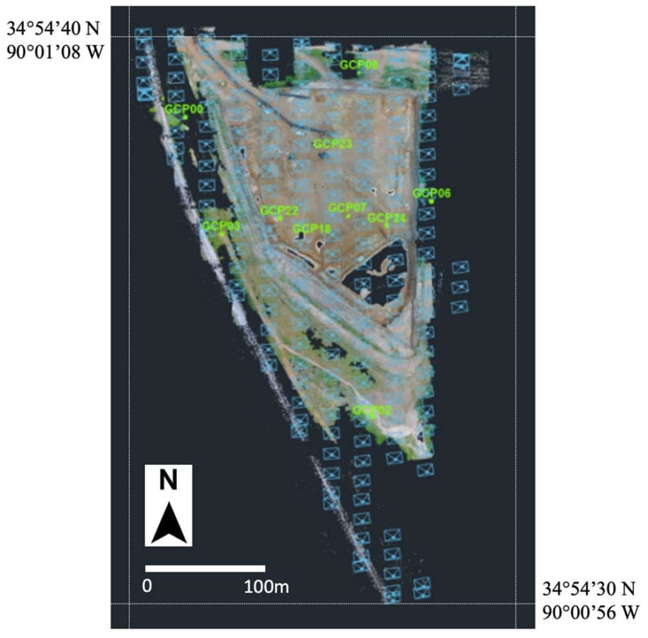
Flight plan of drone for mapping using 3-D Survey. The blue points indicate individual photographs used to create a point cloud of the pit. Ground control survey points are shown in green.
Drones are a cost effective and rapid method for safely photographing large areas that allow for pre-flight elevation and flight path programming. Many areas of the pit were unapproachable because of water in the pit and the potentially unstable near-vertical high walls. The drone allowed access to areas that would not allow a fixed-wing aircraft because of right-angle bends in the highwall. Drone technology permitted various photograph look directions, which allowed researchers to photograph the near-vertical high wall faces. The drone photography also allowed for quick and accurate creation of digital surface models, orthophotos, high wall photomosaics, and 3-D models from the imagery.
This research used a Phantom 4 Pro drone equipped with a 1-inch 20-megapixel CMOS sensor with a field of view of 84° or 8.8 mm. The Phantom model has a maximum flight time of 30 min and can be either controlled manually or operated fully autonomously using a predefined Global Positional System (GPS) path. The camera was mounted on the base of the drone and could be oriented to photograph in any direction. Vertical, oblique, and horizontally oriented photographs were taken at different distances from the high wall to determine good flight distances and look directions for geologic analysis.
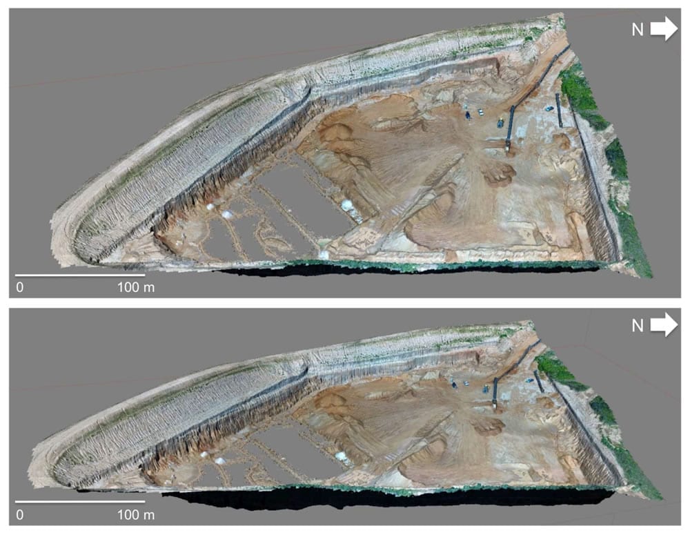
Rotated views of quarry pit using 3D Survey software.
All the drone flights were conducted by 901Drones of Memphis, Tennessee. Ten permanent ground control points (GCP) were placed around the exterior and the interior of the pit, with coordinates surveyed using a GNSS receiver (model: Trimble R8s) with a static maximum precision of 8 mm and 15 mm for horizontal and vertical accuracy, respectively. GCPs were used to provide topographic control of the 3-D models and to calculate photogrammetric accuracy.
For vertical 3-D mapping of the pit, the drone was flown at 200 ft (61 m) above the quarry floor with the camera pointed directly down, and the drone was launched and controlled from within the pit. Approximately 350 images were required to cover the entire pit area and to capture the GCPs on the pit’s perimeter.
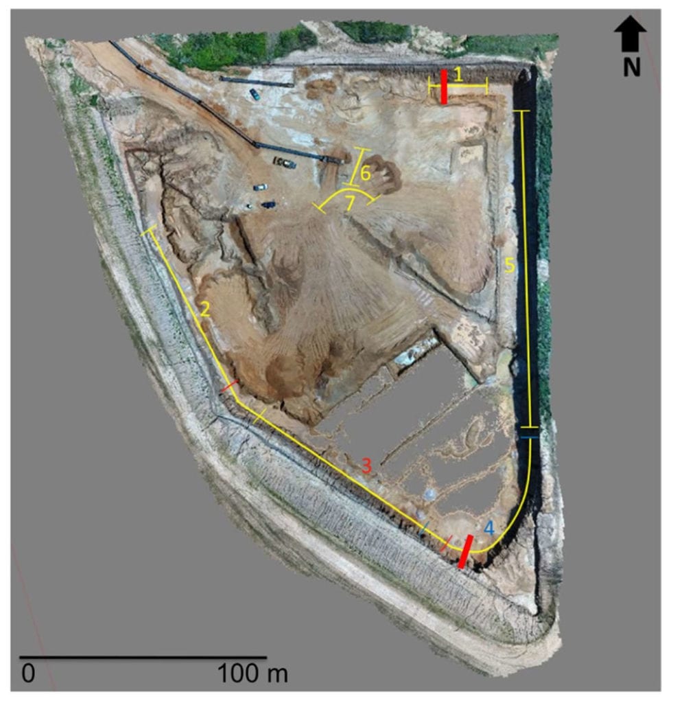
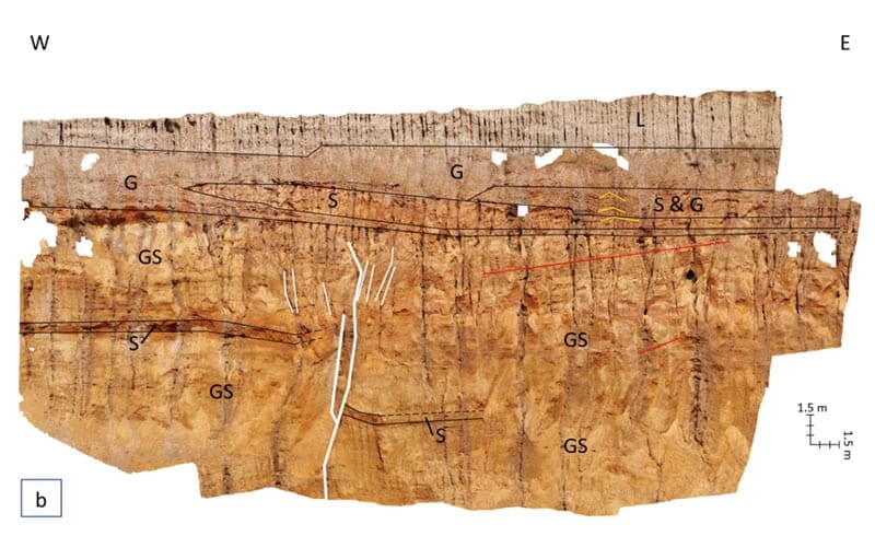
Map view of 3-D model of the quarry pit using 3D Survey software. The numbered yellow lines are the highwalls that were geologically interpreted. The short colored lines that cross the exterior highwalls mark the ends of the highwall with the same colored number. The short bold red line that bisects highwalls 1 and 4 is the location of the fault in Figure 8 and Figure 11.
For analysis of the high walls, two photography perspectives were employed. Drone photography was taken at 90° (horizontal) angles within 25–30 ft (7.6–9.1 m) of the high walls and obliquely at 45° at 20 ft (6.1 m) above the high wall top. All the photos had a minimum of 60% overlap for subsequent 3-D modelling and stereographic viewing to ensure that every part of the area was covered in a minimum of three overlapping images.
Two software packages were used to process the drone photography in this study: 3D Survey (https://www.3dsurvey.si) and Agisoft Photoscan Professional (https://www.agisoft.com).
Conclusions
Drone aerial photography provides a highly effective imaging system for open-pit mining and research of the exposed geology. Aerial drone mapping of the Mississippi River’s Pliocene UC terrace in the Memphis Stone and Gravel active sand and gravel quarry has shown its utility in (1) recording mining progress, (2) identifying and quantifying sedimentary facies geometry, (3) estimating Pliocene Mississippi River paleocurrent directions using cross-bed apparent dip directions, (4) identifying geologic structures, including faults, fractures, folds, and liquefaction, and (5) preserving a digital stereoscopic record of the ancient Mississippi River alluvium that is removed in the mining process.
The high walls also revealed northerly-striking late Pliocene or Pleistocene tectonic folding, faulting, and probable earthquake liquefaction in north-western Mississippi, where no Pliocene or Quaternary tectonic deformation had previously been reported.
Thus, this study identified northerly-striking late Pliocene or Pleistocene faulting that had not been previously documented in DeSoto County, Mississippi. Based on the relationship between fault displacement and earthquake magnitude, an 8-ft (2.4 m) fault displacement could produce a moment magnitude 7.3 earthquakes.
Funding
This research was funded by the DRONES Cluster at the FedEx Institute of Technology at The University of Memphis.
Citation: Drone Geologic Mapping of an Active Sand and Gravel Quarry, Desoto County, Mississippi, Caroline Behrman, Roy Van Arsdale, Youngsang Kwon, Kerry Stockslager, Dave Leverettand David Lumsden, Drones 2019, 3(3), 57; https://doi.org/10.3390/drones3030057, https://www.mdpi.com/2504-446X/3/3/57/htm