
All posts tagged "Aerial Mapping"
-

The Drone Wire
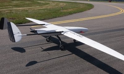
New UAVOS Fixed-Wing Sitaria Completes Test Flight
September 27, 2018UAVOS Inc. has completed a series of test flights of a new Sitaria fixed-wing UAV. The...
-
News
Hangar and Dronebase Team Up to Provide World’s Largest Pilot Network
September 19, 2018Hangar Technology, the world’s first end-to-end platform for 4D Visual Insights, and DroneBase, the largest global...
-
Construction & Mining
Komatsu, Propellor Aero Partner to Bring Drone Analytics to Construction Industry
August 3, 2018With drones becoming an increasingly common worksite tool, Komatsu has identified aerial mapping and analytics as...
-
Industry
SimActive Mapping Software for Precision Agriculture Now in Brazil
June 13, 2018SimActive Inc., a world-leading developer of photogrammetry software, is proud to announce use of its software...
-
Back to Base (B2B)
Aerial Mapping with WingtraOne Drone and Maximilian Boosfeld, Co-Founder, Wingtra
April 17, 2018Swiss UAV manufacturer Wingtra, develop, produce and commercialize drones that combine the ease of use of...


Back To Base (B2B)
