News
Drone Used to Measure Wind Gusts at Low Altitudes Below 500 Meters
Nowadays, small unmanned aerial vehicles (SUAVs) are gaining popularity and have many advancements, leading to them being widely adopted by the commercial sector, consumer market and research communities. Many of the SUAVs are performing missions, such as search and rescue, mapping, environmental studies, aerial imaging and meteorology.
However, since they operate at less than 500 meters above the terrain, their slower flight speeds and lower flight masses of SUAVs also mean that less intense atmospheric turbulence will have a great effect on their flight dynamics and performance.
Study Explores Atmospheric Wind Gusts at Low Altitudes Below 500 Meters
In a new study published in the Journal of Unmanned Vehicle Systems by the Canadian research team of Alton Yeung, Goetz Bramesfeld, Joon Chung, and Stephen Foster, a small unmanned aerial vehicle was developed in order to explore the atmospheric wind gusts at low altitudes below 500 meters. These gusts have significant impact on the flight characteristics and performance of SUAVs.
The authors said:
“Unpredictable atmospheric gusts can create a challenging environment for SUAVs to operate safely and efficiently. Therefore, a representative gust model can help to improve our understanding of the environmental factors and lead to better prediction methods of flight characteristics of SUAVs during low-altitude operations.”
In general, UAVs have become a model for major atmospheric research and a consequence of the continued advancements of smaller and more capable airborne sensors.
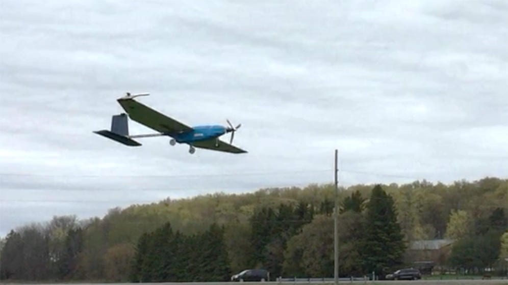
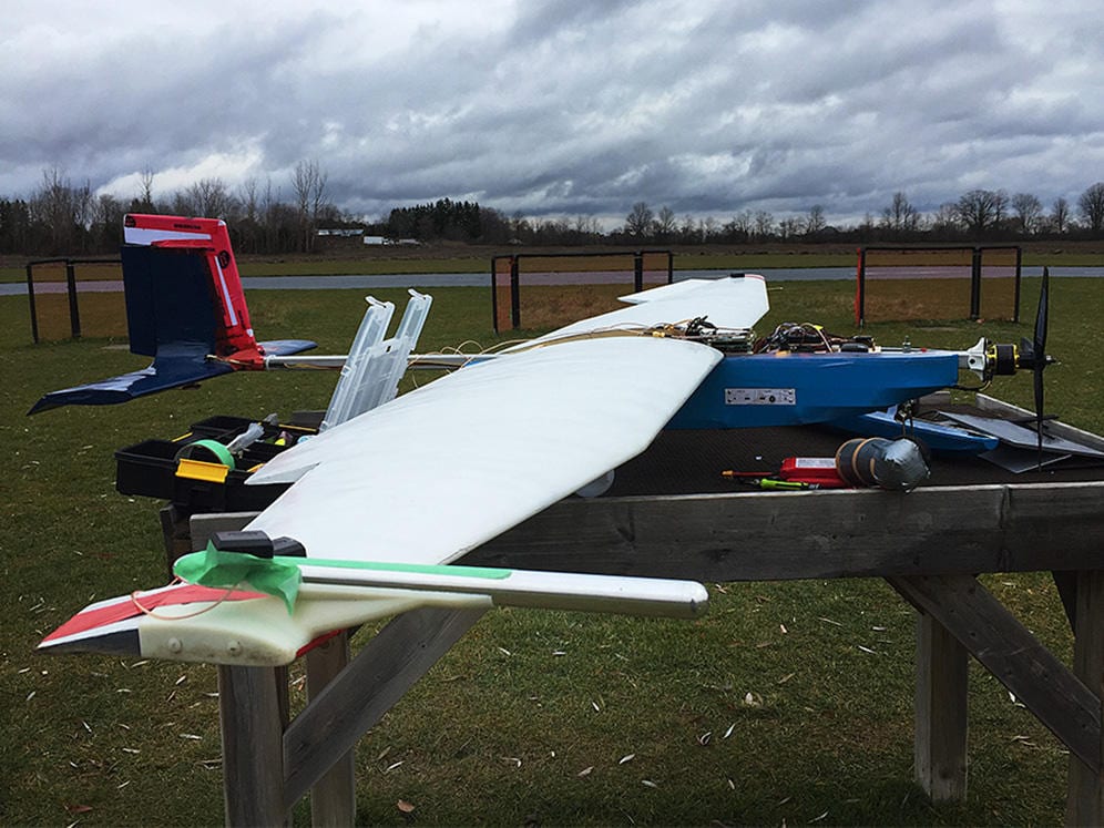
Photo of GustAV aerial research platform flying with a five-hole probe mounted on the wing tip.
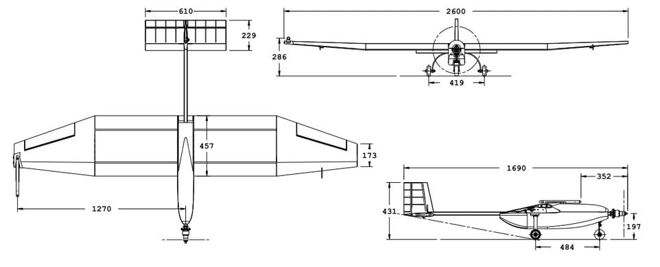
Three-view of GustAV (all dimensions are in mm).
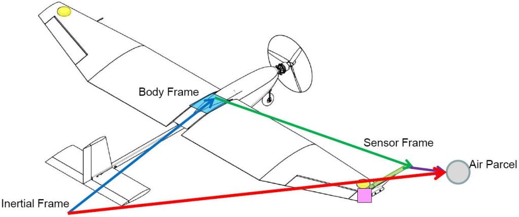
Wind measurement reference frames.
SUAVs And Their Capabilities
This form of development has been further supported by greatly improved autonomous flight-control systems that have made SUAVs highly reliable.
“Many SUAVs are capable of reaching altitudes of over 1000m with payloads of various shapes and sizes. In general, UAVs provide several advantages over manned platforms, for example, they drastically lower operating cost compared with similar missions using manned aircraft. Moreover, electrically powered SUAVs are especially suitable for atmospheric sampling as exhaust gas from an internal combustion engine can cause problems with measuring gas compositions,” the authors stated.

Five-hole probe mounted on the right wing tip of GustAV.
The objectives for the work, as the authors say, are to:
- Develop an autonomous UAV suitable for low-altitude meteorological sensing
- Construct the GustAV and autonomous avionics for autonomous flights
- Perform flight experiments to measure atmospheric gusts at various altitudes
- Extract wind-gust data from the experimental data and compare the results with the other models
Constructing The GustAV – A SUAV Designed To Be Suitable For Flight Tests In Various Remote Locations
GustAV is a SUAV that was designed to be suitable for flight tests at various remote locations. Thus, it is sufficiently robust for field handling and can easily be reconfigured for a variety of experiments.
Its main structure consists of a wing, landing gear, tail and motor which are all mounted to a central aluminum frame. Equipped with a Pixhawk autopilot and controlled using Ardupilot firmware, the payload of GustAV consists of a commercially available air-data system integrated into the airframe.
“This method combines the fast sampling frequency of the IMU at 100 Hz while maintaining the accuracy of the IMU measurements with GNSS solutions. In the event of losing GNSS signal, which is required at 1 Hz to update the error state, the IMU kinematics integration continues to function without interference. The error state is updated once the GNSS solution becomes available again to the Kalman filter. This ensures robustness of the system and sampling frequency of the data acquisition system.”
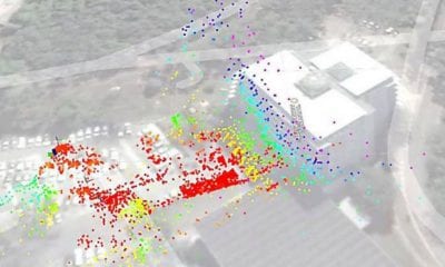
The gust data from the test intervals indicated were converted into power spectral density using using a fast Fourier transformation (FFT) algorithm in MATLAB, showing result of the measured gust spectra at an altitude of 50m.
A Final Word
The turbulence intensities and length scales derived from the flight-test results show that it is difficult to draw a distinctive conclusion. Nevertheless, the flight test data have trends that one expects in general.
“Based on the limited amount of experimental data that were taken, one can conclude that the derived turbulence intensities suggest that there are anisotropic properties in the lower parts of the atmospheric boundary layer in all three directions. Convection in the atmospheric boundary layer during the flight experiment may have contributed to the higher gust intensities that were observed with the flight data in comparison to the MIL-HDBK-1797 model.”
According to the authors, future flight tests should take place to further investigate the turbulence levels at different times of the day and different locations. A regression analysts of measurements taken under different conditions can produce more accurate solutions to turbulence intensities and length scale parameters for the specific surface terrain. In addition to this, large-scale surveying over a longer period of time of a variety of terrain features will produce a more generalized model that can complement the existing model with one that is more suitable for SUAVs operating at low altitudes.
Citation: Measuring low-altitude wind gusts using the unmanned aerial vehicle GustAV, Alton Yeung, Goetz Bramesfeld, Joon Chung, Stephen Foster, Journal of Unmanned Vehicle Systems, 2018, 6:235-248, https://doi.org/10.1139/juvs-2017-0029