News
Using Drones to Classify Forest Tree Species
Nowadays, forest inventory, monitoring and assessment requires accurate tree species identification and mapping. According to recent experiences with multi-spectral data from small fixed-wing and rotary blade unmanned aerial vehicles – there is a role for this technology in the emerging paradigm of enhanced forest inventory (FFI).
The Main Discriminators of Forest Tree Species
According to researcher Steven E. Franklin of Trent University, Ontario, it is the foliage colour, textures and crown shapes that are the main discriminators of forest tree species as a result of differences in reflectance, branching characteristics, geometry and crown growth.
“In the simplest terms, effective UAV-based multi-spectral forest tree species digital classification involves understanding the remote sensing technology, the spectral properties of the features of interest in relation to basic image characteristics, and the area to be covered (mission planning and execution),” the authors note in the introduction.
The list of potential issues in planning and execution of a UAV-based remote sensing operation can be daunting and would include platform and sensor questions. Many small, lightweight rotor-blades on fixed wing UAV systems can deploy broad-band multi-spectral sensors and consumer-grade digital cameras with charge-coupled device or complementary metal-oxide semiconductor detectors.
Franklin conducted a study in five mature mixed wood forests near the village of Orleans in order to prove that UAVs can measure low-altitude forest species. The study focused on nine mature commercial conifer and deciduous tree species: eastern white cedar (Thuja occidentalis), eastern white pine (Pinus strobus), white spruce (Picea glauca), sugar maple (Acer saccharum) (also known as hard maple), red maple (Acer rubrum) (also known as soft maple), aspen (Populus tremuloides), green ash (Fraxinus pennsylvanica), white birch (Betula glauca), and basswood (Tilia americana).
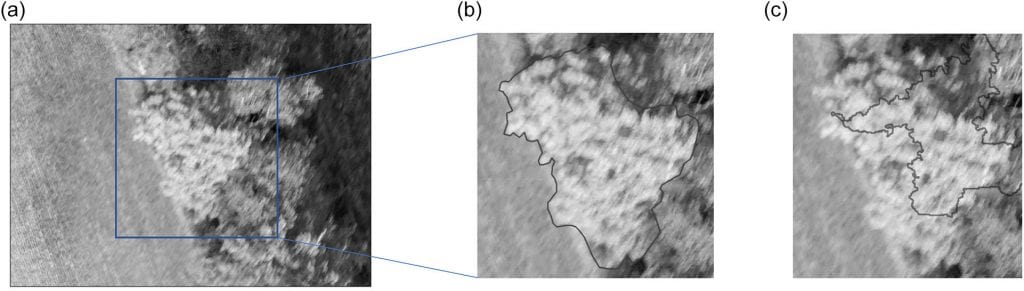
Gray-scale graphical example of a mature sugar maple tree crown for training and validation of pixel-based and object-based classification accuracy: (a) UAV normal colour multispectral imagery, (b) trained airphoto-interpreter manual crown delineation, and (c) automated crown object delineation using OBIA region-growing technique. Area shown in Fig. 2a is approximately 0.25 ha.
Acquiring Images With Precision
In the image and field data collection, images were acquired with a minimum 60% lateral overlap and 80% longitudinal overlap and later processed with Structure-from-motion software to yield point cloud data from which a canopy digital surface model was derived.
There were three main image classification methods implemented in the study, where training and validation data specific to the classifier were used to maintain consistency with the needs of each algorithm.
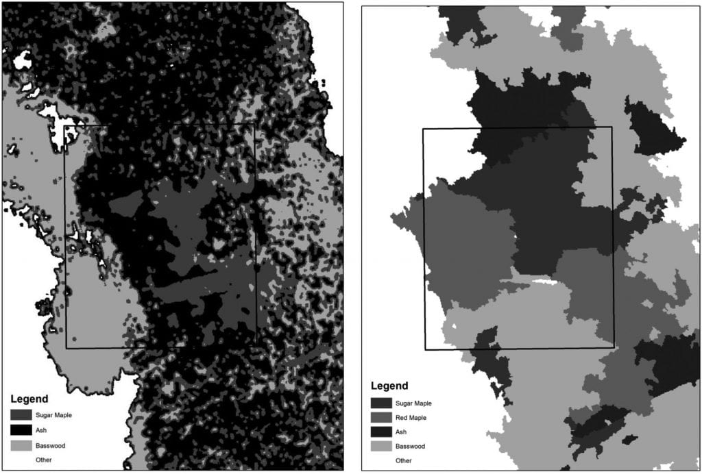
Gray-scale map examples of the best pixel- and object-based classification results with the individual sugar maple tree crown area in Fig. 2 shown in outline. Total area shown in each map is approximately 0.5 ha. Note thatthe pixel-based supervised classification resulted in three tree species identified with approximately 61% accuracy overall; the object-based classification returned four species with approximately 80% accuracy overall.
The methods included:
- “Pixel-based unsupervised clustering used the ISODATA algorithm in ArcGIS (version 10.4)
- Pixel-based maximum-likelihood statistical classifier was based on manually delineated tree crown training areas using PCI Geomatica (version 10.6)
- OBIA employed the Random Forest (RF) machine learning classification algorithm within the R statistical package”
In the present study, the OBIA and RF machine learning classification produced the highest overall accuracy, ranging from approximately 69% to 80%. This was a significant increase over the accuracy obtained using pixel-based unsupervised clustering and supervised maximum likelihood classification methods.
Final Words
In summing up, Franklin suggests that pixel-based unsupervised clustering results in maximum overall classification accuracy of approximately 50%, 60% and 80% respectively for the nine commercial coniferous and deciduous tree species in mature mixed wood forests in central Ontario.
Franklin concludes:
“The overall classification results were generally less accurate than those desired in operational forest inventory programs, which traditionally rely on visual aerial photointerpretation of large-scale photography by trained analysts using local and regional selection and elimination keys. To increase digital classification accuracies with UAV-based multispectral remote sensing data, additional research is warranted in sensor data radiometric, spatial, and temporal characteristics, species-specific variable extraction (e.g., crown shape and structure), automated tree delineation, and more complex decision rule development.”
Citation: Pixel- and object-based multispectral classification of forest tree species from small unmanned aerial vehicles, Steven E. Franklin, Journal of Unmanned Vehicle Systems, 2018, 6:195-211, https://doi.org/10.1139/juvs-2017-0022