News
Drones Capture Erosion of Permafrost Coastline in Canadian Arctic
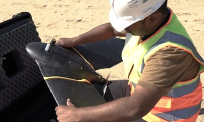
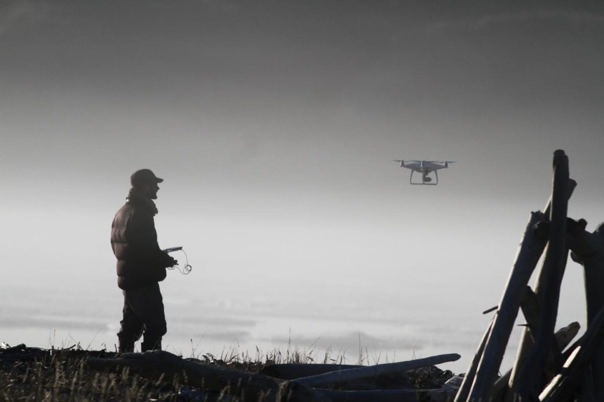
Drone surveys involved in the observation and study of Extreme erosion of Arctic coastlines in a changing climate reveal erosion of up to a metre a day. An international team of researchers led by the University of Edinburgh flew drone-mounted cameras over a section of permafrost coastline on Herschel Island, also known as Qikiqtaruk, off the Yukon coast in the Canadian Arctic.
Increasing amounts of coastal permafrost – frozen ground – which is exposed when sea ice melts during the summer in the Canadian Arctic is being washed away during storms. These are the results of ongoing change in the region caused by warming climate that also leads to longer summer seasons. Sea ice melts earlier and forms again but every successive year the time cycle occurs later than the previous year, leaving the coastline exposed thereby presenting more opportunities for storms to cause damage.
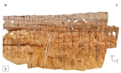
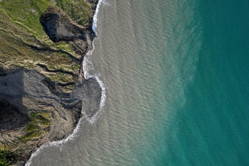
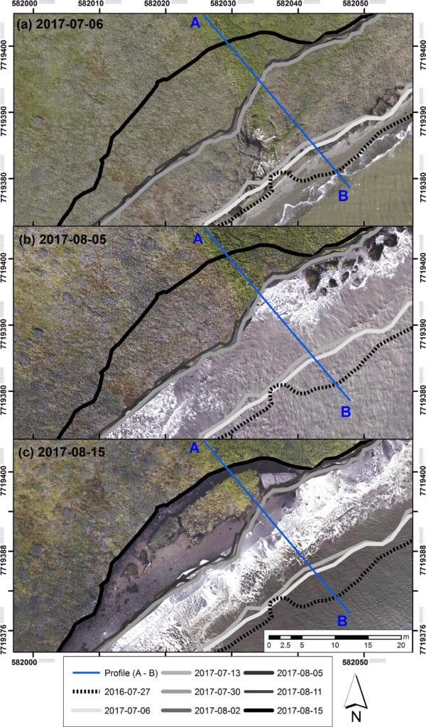
The research team mapped the area seven times over 40 days in the summer of 2017. Their results, from image-based computer models, showed that the coast had retreated by 14.5 metres during the period, sometimes more than a metre a day. Comparison of this data from surveys across 1952 until 2011 showed that the rate of erosion in 2017 was more than six times the long-term average for the area.
Scientists led by the University of Edinburgh used drone-mounted cameras to study erosion of permafrost coastline on Qikiqtaruk – Herschel Island, Yukon Territory, in the Canadian Arctic. Credit: Jeffrey Kerby
The study, published in The Cryosphere, was carried out in collaboration with the University of Exeter, Alfred Wegener Institute, Germany and the GFZ German Research Centre for Geosciences, the Vrije Universiteit Amsterdam and Dartmouth College. Dr Andrew Cunliffe, currently of the University of Exeter’s Geography department, who led the study, said: “As the Arctic continues to warm faster than the rest of our planet, we need to learn more about how these landscapes are changing. Using drones could help researchers and local communities improve monitoring and prediction of future changes in the region.”
Around the Arctic, rapidly changing permafrost landscapes threaten infrastructure essential to local communities such as on Qikiqtaruk – Herschel Island, as well as significant cultural and historic sites.
Dr Isla Myers-Smith, of the University of Edinburgh’s School of GeoSciences, who took part in the study, said: “Big chunks of soil and ground break off the coastline every day, then fall into the waves and get eaten away.”
“As the Arctic continues to warm faster than the rest of our planet, we need to learn more about how these landscapes are changing. Using drones could help researchers and local communities improve monitoring and prediction of future changes in the region.” Dr Andrew Cunliffe, Geography department, University of Exeter
Drones played in crucial role in helping Environmental scientists gather and analyse data of the erosion permafrost coastline. The alarming increased rate of erosion from 2017 onwards makes conservation efforts even more imperative.
The study was supported by the UK Natural Environment Research Council, the National Geographic Society, and Horizon 2020.
Citation: Rapid retreat of permafrost coastline observed with aerial drone photogrammetry, Andrew M. Cunliffe, George Tanski, Boris Radosavljevic, William F. Palmer, Torsten Sachs, Hugues Lantuit, Jeffrey T. Kerby, and Isla H. Myers-Smith, The Cryosphere, 13, 1513-1528, 2019, https://doi.org/10.5194/tc-13-1513-2019