News
Using Drones to Monitor Peatlands
Using Drones to Monitor Peatlands
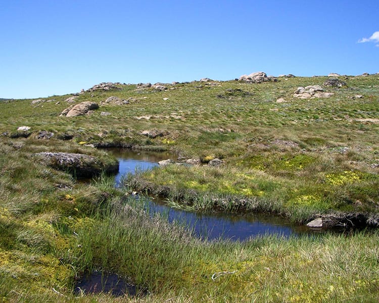
Nowadays, both the sub-alpine and alpine peatlands in Australia are constrained to poorly drained areas. If you are new to the concept of peatlands, they are basically wetlands with low mineral content as well as an organic soil layer of at least 30 cm depth. Since they maintain a low decomposition rate, they are a major global carbon sink that covers barely 3% of the Earth’s surface, boreal and subarctic peatlands which results in a net cooling effect on the Earth’s climate. Aside from this, peatlands are crucial water flow regulators and efficiently store surface water, filtering out sediment and moderating runoff.
A Study that Tests the Viability of Creating Sustainable Peatland Monitoring Models
This is what motivated a group of authors to develop a study and test the viability of creating such hydrological models. Their case study was also used to test three different ground control point (GCP) scenarios in order to assess the effect on DSM quality.
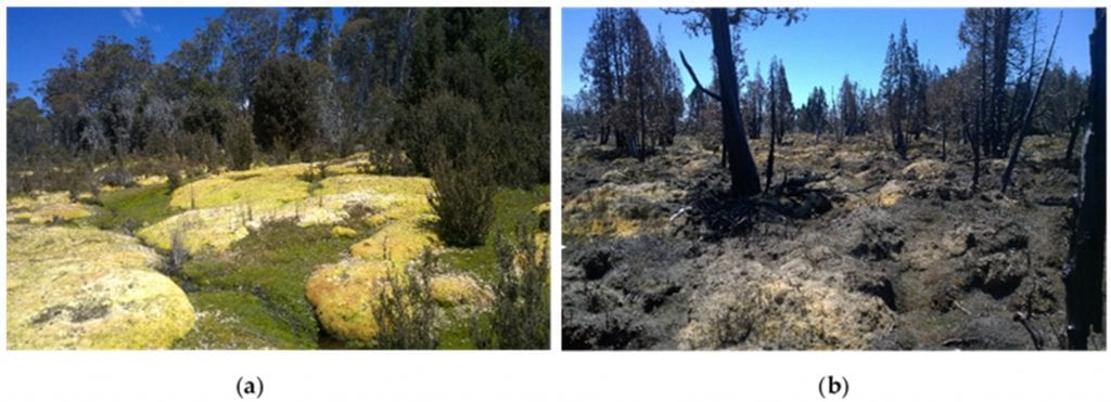
(a) Healthy sphagnum from Skullbone Plains, near Bronte Park, Central Tasmania; (b) Post-fire conditions of burnt Sphagnum and pencil pine trees near Lake Mackenzie, Northern Tasmania.
In the study, the authors see Sphagnum is an important contributor to the resilience of peatlands but also a factor that is very sensitive to fire and often shows slow recovery after being damaged. As they describe it:
“Sphagnum, a large colonial bryophyte, is considered to be an important contributor to the resilience of sub-alpine and alpine peatlands, as it can easily survive under extremely nutrient-poor conditions and can produce resistant organic matter which further promotes peat accumulation [1,8,12]. Sphagnum mires are also an important habitat for several wildlife species including endangered frogs, such as the Corroboree frog.”
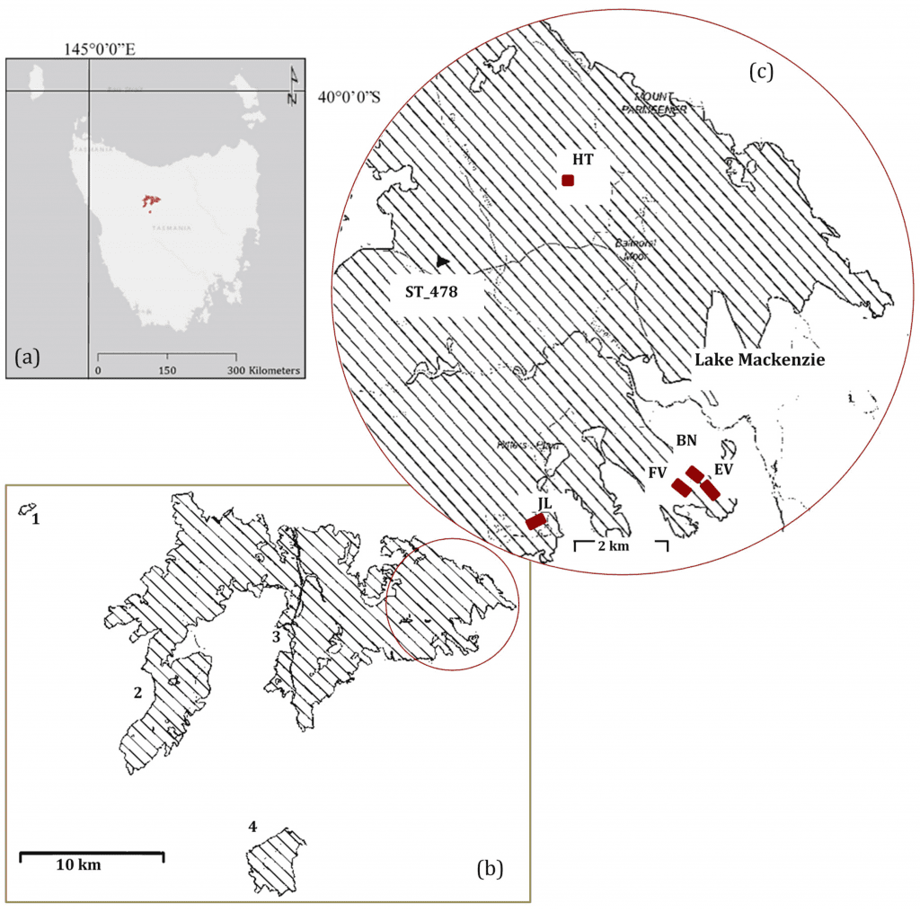
Fire boundary of the Mersey Fire Complex (2016) in Tasmania; (b) Ignition points at 1. Dove River, 2. February Plains, 3. Mersey Forests, 4. Lake Bill; (c) Locations of the study sites are shown and the location of the RTK DGPS Base station, placed on marker ST_478.
A Reasonable Solution Through the Use of High-Spatial Resolution Imagery
Therefore, monitoring the peatlands in Australia seems like a reasonable solution that can be easily achieved by capturing ultra-high spatial resolution imagery from unmanned aerial systems (UAS) commonly known as drones. There are various high resolution digital surface models (DSMs) that can be created from UAS imagery from which various hydrological models can be derived – all in order to monitor the hydrological changes as well as assist in the rehabilitation of the damaged peatlands.
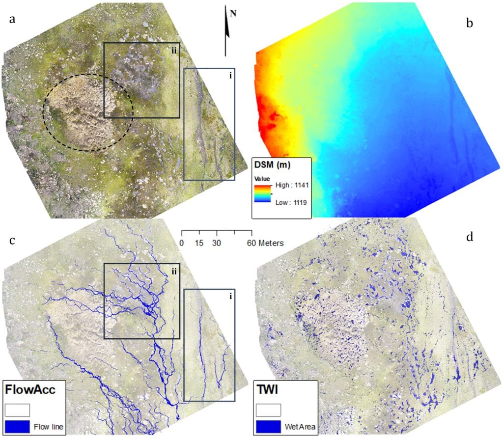
Orthophoto of the Heath study site with a dashed circle indicating the position of Sphagnum peatlands; (b) DSM from the reference scenario; (c) flow accumulation model derived from reference DSM; and (d) topographic wetness index map derived from the reference DSM.
In times when there are numerous records of peatland damage ranging from wildfires to other factors that lead to loss of peat soils, specific monitoring actions have to be put in place.
As the authors note:
“To make peatland rehabilitation methods more efficient and effective, an improved knowledge of the response of peatlands to disturbances is required [1,7,22]. Current physical mapping and monitoring techniques of Australia’s peatlands, such as described by Whinam et al. [18] and Clarke and Martin [23], are often labor intensive, time consuming, and can further damage peatlands by stepping on this delicate vegetation. Additionally, the use of sample areas (quadrats and transects) generally covers only 1–4% of the peatland being studied, hence, are vulnerable to sampling bias. Alternatively, conventional remote sensing techniques such as satellites and aerial photography are inefficient for peatland monitoring due to the fragmented nature and typically small areas (<1–2 ha) of individual peatlands in Australia.”
The Concept of UAS for Monitoring Peatlands
From this, it is obvious to see that peatlands can only be properly evaluated and monitored with a technology that goes beyond the benefits of standard imagery. This is how the concept of unmanned aerial systems (UAS) comes to mind and how it can capture the micro-topography of peatlands, essential in their monitoring and essential to the hydrological pathways and peat bog volumes.
In their study, the authors use specific materials such as an UAS platform under the DJI Phantom 4 Pro, a georeferencing focus through the Agisoft Photoscan software, accuracy assessment and a specific algorithm. The results led to a few hypotheses that could explain the overall higher accuracy performances of these systems.
As the authors found:
“The aim of this methodology was to effectively control the second image dataset based on the first, if this were successful it would mean that once there is an accurately controlled model of a site, subsequent image collections would not need control as they could be matched to the earlier dataset. This method requires the scenes to have sufficient elements that remain unchanged over time, such that features can be matched between the two datasets. It was hypothesized that this would work for the peatlands as they contain a lot of rocks that will not change over relatively short time frames.”
Conclusion
There are a lot of hydrological models that could be born thanks to this study. Its objective, after all, was to show that digital surface models (DSMs) of Sphagnum dominated peatlands can be subjects to accurate georeferencing.
Citation: “Using Digital Surface Models from UAS Imagery of Fire Damaged Sphagnum Peatlands for Monitoring and Hydrological Restoration”, Shannon de Roos 1, Darren Turner, Arko Lucieer and David M. J. S. Bowman, Drones 2018, 2(4), 45; doi:10.3390/drones2040045 – https://www.mdpi.com/2504-446X/2/4/45/htm