News
The Use of Drones in Conservation
As of recently, unmanned aerial vehicles (UAVs) or drones have been called upon to revolutionize the conservation and protected areas. Their potential is wide and was seen in raising better-informed decisions to assist management. Cost-effective and innovative, the solutions employing drones can cater to a variety of environmental problems that threaten biodiversity in protected areas.
The Benefits of Drone Applications in Distinct Areas
Speaking of, the benefit that drones could bring are numerous and remain fundamentally unexplored. In order to address them, two researchers, Jesús Jiménez López and Margarita Mulero-Pázmány, have published a paper in which they outlined their thesis and classified the studies in five distinct areas of applications including:
- wildlife monitoring and management;
- ecosystem monitoring;
- law enforcement;
- ecotourism; and
- environmental management and disaster response
According to the authors of the paper titled, ‘Drones for Conservation in Protected Areas: Present and Future’, drones have been a subject of a growing interest in both the civilian and scientific spheres. As such, they have pioneered a new distinct era of remote sensing for the study of the environment. Nowadays, drones offer a relatively risk-free and low-cost manner to rapidly and systematically observe the natural phenomena at high spatio-temporal resolution.
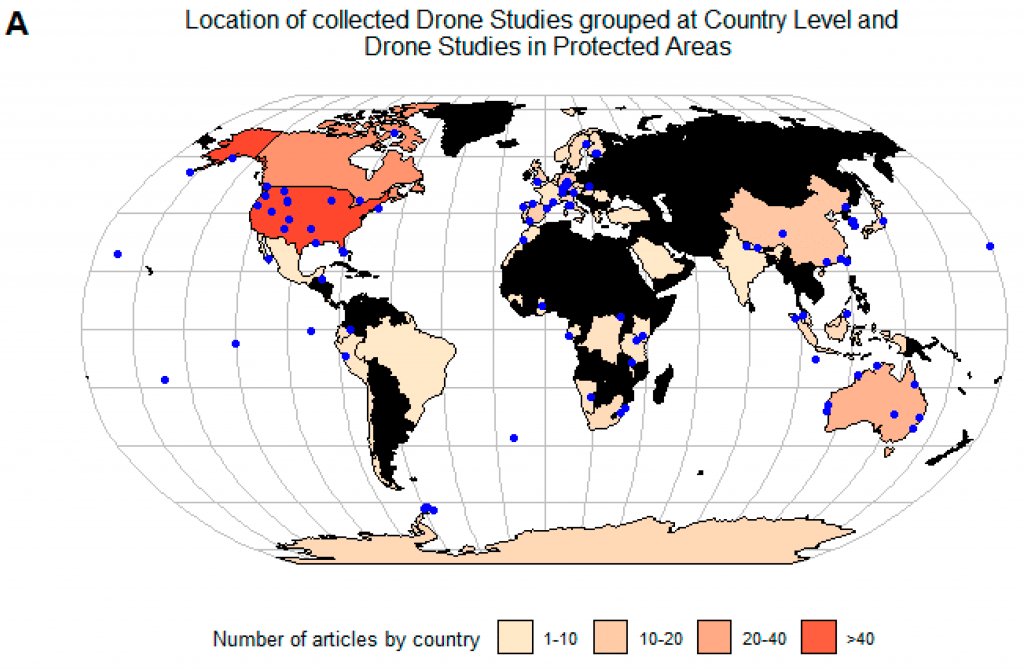
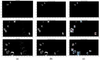
Blue points represent studies in protected areas. Choropleth map shows location of studies by country. No studies were collected in countries colored black.
![(B) Only studies where type of platform was identified are shown. (C) Information extracted from WWF Terrestrial Ecoregions Map [42]. No drone studies were found in Protected Areas with Tropical and subtropical dry broadleaf forests.](http://dronebelow.com/wp-content/uploads/2019/01/drones-03-00010-g001b-863x1024.png)
(B) Only studies where type of platform was identified are shown. (C) Information extracted from WWF Terrestrial Ecoregions Map [42]. No drone studies were found in Protected Areas with Tropical and subtropical dry broadleaf forests.
“The success of drones can be partially explained by their great flexibility to carry different sensors and devices. The scope of application determines the best combination of aerial platform and payload. Although drones come in many different shapes and sizes, widespread small fixed-wing and rotary-wing aircrafts are frequently used for video and still photography. These consumer grade drones coupled with lightweight cameras and multispectral sensors can deliver professional mapping solutions at a fraction of a cost than previous photogrammetric techniques.”
Benefiting the Ecology and Vegetation Studies
From this, it is easy to see that medium size drones can be used in these industries. Equipped with compact thermal vision cameras, hyperspectral sensors and laser scanning (LiDAR) technology, they can benefit many wildlife ecology and vegetation studies as well as forestry applications.
From search and rescue, protecting endangered turtles from feral species, invasive plant species, illegal logging and mining, wetland management, anti-poaching and marine litter detection, the use of drones expands and exceeds previous expectations while giving rise to singular circumstances.
The methods in the study, as mentioned by the authors, focus on the studies into categories that represent the common threats and essential management measures in protected areas. The authors briefly tackled legal and ethical issues, including potential impact on wildlife and habitats as well as the general economic and technological factors of drones which shape up their use in conservation and environmental issues.
Conclusion
As the results from more than 256 studies (evaluated by the authors of this paper) show, there are a lot of challenges for the future integration of drones in protected areas. From the costs of drone operation to the technological challenges and conservation issues, the general conclusion is as following.
“The variety of information gathered from drones represents a great opportunity to complement ongoing Earth Observation programs aimed to monitor anthropogenic pressures threatening the ecological integrity of protected areas [244]. Drones can be rapidly deployed there, where early sign of disturbance have been previously detected using satellite images and environmental sensor networks [245]. Although many protected areas are too large to be mapped using drones, there are small, inaccessible and environmentally sensitive terrestrial and marine areas (ESAs) with important ecological values that could take advantage from drones. Once the use of drones has proven feasible in many different fields of application, it would be of interest that research focuses on methods to produce a set of ecological indicators in line with established monitoring frameworks.”
So, the end conclusion puts drones in line with a wide range of biodiversity metrics, ecosystem processes as well as natural and anthropogenic stressors which could transfer the advances on the field into accessible products for direct use at management levels.
Citation: Drones for Conservation in Protected Areas: Present and Future, Jesús Jiménez López and Margarita Mulero-Pázmány, Drones 2019, 3(1), 10; doi:10.3390/drones3010010, https://www.mdpi.com/2504-446X/3/1/10/htm