
All posts tagged "Mapping"
-

News
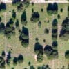
Analysis of Orthomosaics Derived from Drone Imagery
June 5, 2019The advancements in drone technology has revolutionized the production of aerial imagery. Using a drone equipped...
-
News
DOWSE, A DrOne Water Sampling SystEm
May 29, 2019Testing water samples from large water bodies at regular intervals is an imperative yet sometimes tedious...
-
News
Drones Map Radiation in Chernobyl Exclusion Zone
May 9, 2019Drones and Artificial Intelligence (AI) combined have yet again emerged as the perfect solution for reconnaissance...
-
Conservation
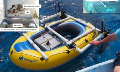
Low-Cost Autonomous Rubber Dinghy for Mapping and Monitoring Coral Reefs
April 24, 2019Researchers are now exploring the use of recent advances in open source Global Positioning System (GPS)-guided...
-
Brands
DJI Terra – Capture, Analyze and Visualize
March 29, 2019DJI, the world’s leader in civilian drones and aerial imaging technology, today introduced DJI Terra has...


Back To Base (B2B)
