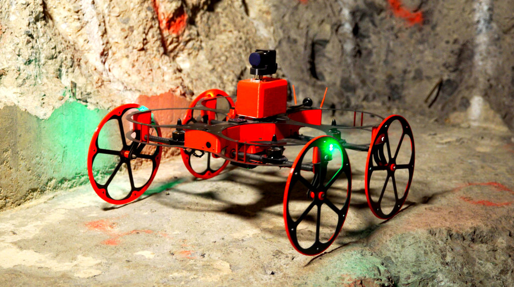
TILT Ranger Hybrid Land/Air Drone for Underground Mines
Inkonova AB, in collaboration with Clickmox Solutions Inc., has developed the World’s First Drone Solution intended for underground mines, tunnels, and other similar dark and constricted areas.
The main features of the drone include laser scanning designed for 3D laser scanning, hybrid navigation for flying, running and climbing, flight time of up to 20-min with single battery configuration, payload capacity of up to 1 kg, and carbon-fiber-integrated main body propeller protectors for propeller protection.
Headquartered in Stockholm, Inkonova AB is a startup company specializing in developing unmanned aerial systems (UAS), unmanned aerial vehicle (UAV), mining drones, drone solutions, and hybrid drones.
The Canadian company, Clickmox Solutions Inc., based out of Ontario, offers products and services for mining and industrial segments across the globe in areas such as robotics, point cloud data processing, 3D LiDAR scanning, geotechnical monitoring, simulations, and convergence monitoring.
Due to errant planning, delays, and no-gos, millions of dollars are lost every year in many underground mines. The issues are either the underground mines cannot be accessed or do not allow scanning of certain zones.
The current boom-mounted CMS that is being used as a solution create blind zones as certain spots could not be scanned, wherein those data are significant to the surveyors and mine operators.
The land–air hybrid drone, TILT Ranger, was developed with tilt-rotor technology. The drone can fly, run, climb, and scans zones that are inaccessible, making it most suitable to be used in underground mines and other tightly spaced environments akin to underground mines.
The TILT Ranger produces an output of 3D laser point cloud map, using simultaneous localization and mapping (SLAM) along with video footages. The point cloud map can be used as-is or can be processed to extract important information required for underground mines or facility managers.
The custom-made TILT Ranger was set up in the Loulou gold mines in Mali (Africa) for stope scans. The commissioned TILT Ranger was expected to scan three stopes that are inaccessible in the gold mine. For some stopes, Beyond Visual Line of Sight (BVLOS) flights were also conducted.
In situations in which video scans or terrestrial access was not applicable exclusively, the two important requirements of laser scanning and aerial–terrestrial hybrid access were addressed by the TILT Ranger.
Although intense smoke stopped the completion of scan in one stope, the inbuilt software successfully generated a 3D model for the remaining two stopes, with the help of SLAM technology.
Inkonova AB, founded in 2014, commercialized their tilt-rotor technology as “racing drones” in the following year, and is currently working toward an automated solution using Bat-onomous Navigation, to make it easy to operate for mine workers.
Sources:
- https://www.youtube.com/watch?v=hk7CxtFSg44
- https://www.linkedin.com/company/3856556/
- http://www.clickmox.com/
- http://www.clickmox.com/about.html
- http://inkonova.se/
- http://inkonova.se/tilt-ranger/
- http://inkonova.se/cases/stope-scans-underground-gold-mines-loulou-mali-africa/