News
Drone-Based 3D Photogrammetry for Post-Earthquake Evaluation
Meaningful data is something considered extremely valuable in terms of understanding natural phenomena, different areas, consequences of natural and artificial disasters and processing and solving the said data to finally arrive to preventative measures or solutions for different problems.
Data acquisition means and techniques have varied through the ages, as we once used to carve on stones, moved on to writing and drawing, then to typing, recording and photographing and now, to use our understanding of interpreting recordings in the form of image acquisition, image processing and photogrammetry.
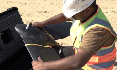
Photogrammetry requires a tool for recording videos; while fixed cameras are a great means of making such recordings, drones or Unmanned Aerial Vehicles (UAVs) make much efficient and active tools for image acquisition.
A case study titled, ‘UAV-based 3D Photogrammetry for post-Earthquake Studies on Seismic damaged Cities – A Case Study: Castelluccio di Norcia‘, published under International Conference on Education and Information Systems, Technologies and Applications effectively analyzes the usage of UAVs for 3d image processing of sites affected by Earthquakes.
You might have been wondering, “What exactly is photogrammetry?”
Well, Photogrammetry is the science of making measurements from photographs, especially for recovering the exact positions of surface points. In short, photogrammetry means looking at something and deciding its dimensions at a very high accuracy digitally.
Aerial surveying: Before moving to UAV based photogrammetry, the paper proposed how aerial surveying has been under usage before.
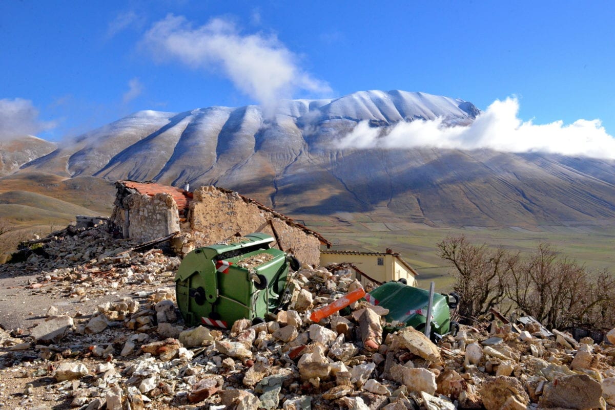
After the two earthquakes of August and October in Central Italy, the Fire Department and the Civil Protection flew over the village with helicopters and drones (UAVs), in order to detect the state and extension of damage. Clearly, because of the high risk related to the presence of rubbles and to falling material from damaged buildings, the aerial survey was the most effective and safe methodology to achieve a correct global mapping of the damage on buildings.
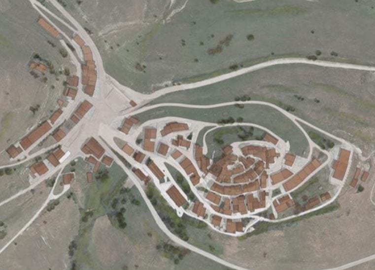
Framework of the village of Castelluccio di Norcia before the earthquake of October 30th.
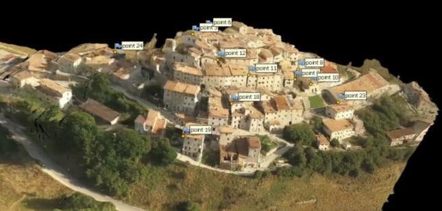
Location of GCPs in the model of the pre-earthquake phase
Digital surveying: The widespread use and development of digital survey technologies that our generation witnessed in the last decades have made it possible to apply the three-dimensional (3D) metric survey in the fields of architecture and civil engineering, which is now commonly categorized under photogrammetry, described already. Another means of digital surveying or digital topography is laser scanning.
While surveying techniques have been around, modern tools and techniques for the photohrammetry methodology offer a significant improvement over the conventional means:
In particular, what distinguishes the latest technologies from the previous survey methods are:
- The fully automated or semi-automated mode of operating, in terms of determining the internal camera geometry and camera position and orientation;
- The modest cost of the survey instruments;
- The presence of numerous low-cost or open source software options, with easy-to-use interfaces, for data processing.
How does photogrammetry work?
Let us briefly understand how exactly it is possible to record videos of an object or take images, and convert it into accurate dimensions of the object; photogrammetry.
- The workflow consists of a first phase in which multiple views of an object are captured from different positions by a digital camera.
- The set of images is therefore transferred in a software, which calculates and identifies homologous points in the set of images. So essentially, the system connects the images and is able to establish the position of the cameras in an arbitrary 3D coordinate system.
- By calculating the distance from the camera to the object, the system produces a self-calibrating bundle-adjustment and transforms the measured image coordinates into 3D points covering the area of interest.
- The automation of image-based 3D modeling processing is made possible thanks to the use of algorithms derived from computer vision studies.
UAVs and Photogrammetry
The primary reasons why UAVs or drones installed with equipment used for image processing and photogrammetry would be that drones do not require physical presence of people around areas that are under threats, can be maneuvered very effectively, can be taken to regions that are difficult to access and pose lethal risks and offer very efficient results.
With the application of UAV-based photogrammetry, real-scale models of the study area can be obtained. This means that studies on damage assessment, vulnerability of existing structures and collapse mechanisms on buildings can be carried out even if there are problems related to the of access and inspection of certain areas.
UAV based inspection of the aftermaths of the Earthquake in Central Italy in 2016 provide accurate results that have been researched and refined as they form a topology of entire towns and villages; greatly helping in the assessment of the damage on an architectural level.
Citation: UAV-based 3D Photogrammetry for post-Earthquake Studies on Seismic damaged Cities – A Case Study: Castelluccio di Norcia. Martínez-Espejo Zaragoza, Isabel & Croce, Valeria. (2018) | https://www.researchgate.net/profile/Isabel_Martinez-Espejo_Zaragoza/publication/327318831_UAV-based_3D_Photogrammetry_for_post-Earthquake_Studies_on_Seismic_damaged_Cities_-_A_Case_Study_Castelluccio_di_Norcia/links/5b8811b192851c1e123c09a0/UAV-based-3D-Photogrammetry-for-post-Earthquake-Studies-on-Seismic-damaged-Cities-A-Case-Study-Castelluccio-di-Norcia.pdf