News
Swarm Technology for Drone Photography Over Large Areas
Photogrammetric analysis of a flat landscape is quite simple as a drone simply needs to take pictures at different locations flying over the area specified. This process, however, can get extremely complicated when an analysis of a spatially complex area is required; such as one with buildings or a disaster cite. In such cases, photogrammetry requires long flight times and a lot of processing power; frequently associated with variable light- and meteorological conditions during periods spanning several days. This is especially true for drone copters.
Working on improving the photogrammetric process using drones, a paper published in the International Journal of Latest Research in Science and Technology titled, ‘Swarm-technology for Large-area Photogrammetry Survey and Spatially Complex 3D Modelling’, utilizes swarm technology to address the problems when performing photogrammetric analysis of complex landscapes.
Swarm Technology
Drone swarming is a relatively new field of robotics research. Swarm technology enables drones to perform as an intelligent group, interpreting what is happening in real-time and self-organize. Using appropriate software, drones can ascend synchronously, communicate with each other and create cross-references. Drones flying in cooperation can create networks and transfer information. They can be used as mobile radio stations or WLAN transmitters in regions lacking infrastructure.
Photogrammetry with Swarm Technology
It is a rule of thumb for photogrammetry, the more pictures captured in an area, the better the results. For areas spanning a few square kilometers, very long flight times and power would be required. To address this requirement, commercial-off-the-shelve (COTS) and cheap UAVs developed in bulk were used by the Austrian researchers. Multiple UAVs would form a swarm of drones and provide a large number of photos of a specified ar ea that were used for 3d modelling of the area; in significantly less time as compared to using individual drones that work independently.
The advantages of using swarm technology for photogrammetry of spatially complex structures are,
- COTS: Using cheap, commercially available drones ensures convenient availability of the drones, cheap maintenance and easy integration of the said drones with commercial softwares.
- Shorter Operational Time: With several drones collaborating for a single task, the total time taken by a swarm is much smaller than the time taken by a single drone; the total time reducing directly with the number of drones used.
- Less Variable Boundary Conditions: Since each drone within a swarm does not have to cover a very large area, the variations in meteorological conditions and light conditions is much smaller for a drone working in a swarm as compared to an independent drone working individually.
Experimentation and Verification
A number of DJI Mavic Pro were used for the swarm mainly due to their numerous sensor systems; Sonar, Infra-red as well as image processing. Three different flight modes were incorporated in the Mavic Pro drones.
- Obstacle avoidance: Using the sensors mounted on the drone, it was able to clear obstacles such as vehicles, buildings and people.
- Active Track: The cameras were used to allow the drone to track objects, such as people.
- TapFly: The drone has a “point and fly” feature as per which it flies directly to any location pointed out on the screen; this feature is integrated with obstacle avoidance so the drone moves towards the set location without hitting any objects along the way.
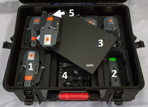
Photogrammetry Swarm Transport Container: (1) Five UAVs-model DJI MP; (2) Ten spare batteries; (3) Notebook computer; (4) Battery charger
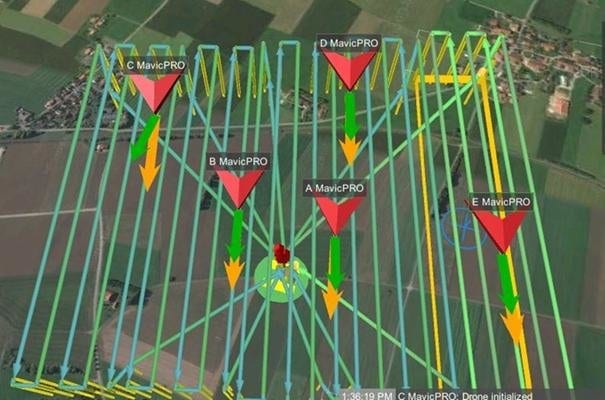
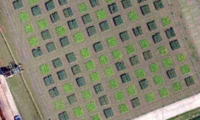
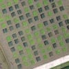
Pre-programmed large area Way Point-flight routes for photogrammetry swarm consisting of five MP drones (Code A to E).
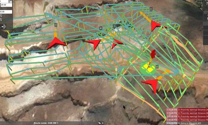
PSH flight mission planning for high resolution (< 1 cm accuracy deformation measurement)3D photogrammetry model of surface mine, ZAB-Erzberg (Austria).

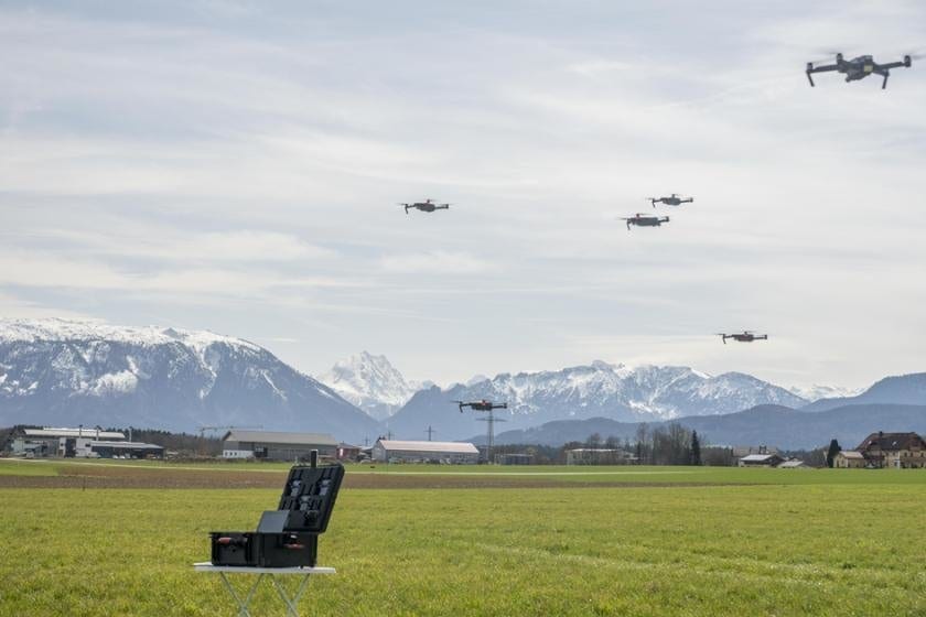
Photogrammetry Swarm in action, with five MP drones in swarm formation hovering above the transport container during a test flight in 2018; a sixth drone is filming the swarm.
International Security Competence Centre GmbH (ISCC), in cooperation with GEORESEARCH Forschungsgesellschaft mbH, developed a Photogrammetry Swarm Kit (PSK) that included the control systems for the Mavic Pro drones to operate. The kit allows assignment of sub-areas of a total area to each one of the five drones in the swarm, some parts of the sub-areas are highlighted at higher resolutions, each drone was configured to record complex objects at a set angle and location; the integration of the results from all five drones would form a valuable photogrammetric result.
Extensive field tests were performed in Austria, Germany and Kyrgyzstan with considerably accurate 3d models produced.
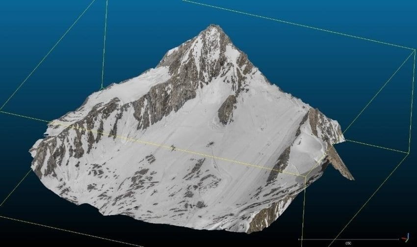
Photorealistic 3D photogrammetry model of Austrian glacierKitzsteinhorn (altitude: 3 200m; area: 2.8km²) using PSK; total flight time for mission: 17 min.
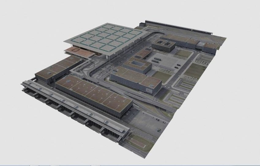
Photorealistic 3D photogrammetry model of airport terminal, Berlin (Germany).
Conclusion
The photogrammetry kit (PSK) enables a user to program a swarm of drones and operate them according to the set programming. The swarm was able to create high-resolution 3d models of large areas with the added benefit being that the swarm technology took significantly less time a single drone, making it much convenient for the task and much more cost-effective.
Using a drone swarm as compared to a single drone,
- Operational time can be shortened by significant amounts.
- Image quality can be improved reasonably.
- Using COTS drones instead of specially designed, custom drones reduces initial investment in the system.
Citation: Auer, Lukas & Feichtner, Andreas & Steinhäusler, Friedrich & Delleske, Robert & Keuschnig, Markus. (2018). Swarm-technology for Large-area Photogrammetry Survey and Spatially Complex 3D Modelling. International Journal of Latest Research in Science and Technology. 04. 33-39. https://www.researchgate.net/publication/328149194_Swarm-technology_for_Large-area_Photogrammetry_Survey_and_Spatially_Complex_3D_Modelling