
All posts tagged "Mapping"
-

Industry
Simulating Real-Time Hyperspectral Processing Algorithms On-Board Drones
August 29, 2019Hyperspectral imaging technology has been gaining popularity over the years primarily due to its ability to...
-
News
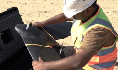
UAE Using Drones and AI to Map Desert Landscape
August 6, 2019Drone technology is now assisting with census and mapping of wildlife and green cover in a...
-
Construction & Mining
Drone Mapping of Mississippi Quarry
July 19, 2019Unmanned Aerial Vehicle (UAV) or drone technology is becoming more and more valuable in geologic investigations...
-
News
Scientists Use Drones to Map Guam’s Coral Reefs
June 27, 2019Researchers from NASA and the University of Guam have successfully mapped a large stretch the topography...
-
News
Drones Capture Erosion of Permafrost Coastline in Canadian Arctic
June 11, 2019Drone surveys involved in the observation and study of Extreme erosion of Arctic coastlines in a...


Back To Base (B2B)
