
All posts tagged "Mapping"
-

News
Drone-Based 3D Photogrammetry for Post-Earthquake Evaluation
September 25, 2018Meaningful data is something considered extremely valuable in terms of understanding natural phenomena, different areas, consequences...
-
News
Scene 3D Sketching for Drones
September 24, 2018Unmanned Aerial Vehicles (UAVs) have begun to gain popularity in industry, especially given that autonomous and...
-
News
Analysis of mapKITE – New Drone-Based Concept for Geo-Data Acquisition
September 20, 2018The legal frameworks of unmanned aerial vehicles (UAVs), also known as drones, is quite extensive. However,...
-
News
Hangar and Dronebase Team Up to Provide World’s Largest Pilot Network
September 19, 2018Hangar Technology, the world’s first end-to-end platform for 4D Visual Insights, and DroneBase, the largest global...
-
News
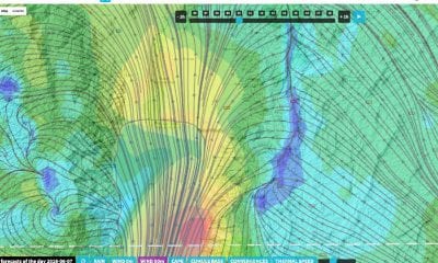
Soar & Atmosoar Partner in Drone Weather Forecasting Technology
August 24, 2018The signing of a new partnership memorandum between Hong Kong and Italy has also brought a...


Back To Base (B2B)
